You are here: Home > Network List > IU - Global Seismograph Network (GSN - IRIS/USGS) Stations List
> Station RSSD Black Hills, South Dakota, USA > Earthquake Result Viewer
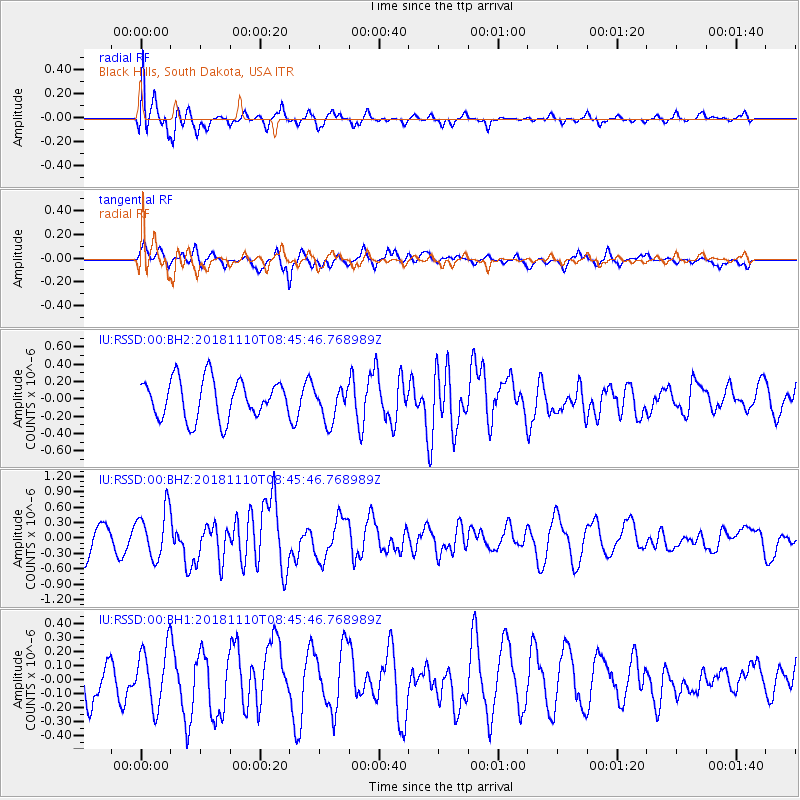
RSSD Black Hills, South Dakota, USA - Earthquake Result Viewer
*The percent match for this event was below the threshold and hence no stack was calculated.
| Earthquake location: |
Tonga Islands |
| Earthquake latitude/longitude: |
-20.5/-173.8 |
| Earthquake time(UTC): |
2018/11/10 (314) 08:33:16 GMT |
| Earthquake Depth: |
10 km |
| Earthquake Magnitude: |
6.2 Mww |
| Earthquake Catalog/Contributor: |
NEIC PDE/us |
|
| Network: |
IU Global Seismograph Network (GSN - IRIS/USGS) |
| Station: |
RSSD Black Hills, South Dakota, USA |
| Lat/Lon: |
44.12 N/104.04 W |
| Elevation: |
2090 m |
|
| Distance: |
90.5 deg |
| Az: |
42.521 deg |
| Baz: |
241.584 deg |
| Ray Param: |
$rayparam |
*The percent match for this event was below the threshold and hence was not used in the summary stack. |
|
| Radial Match: |
73.53814 % |
| Radial Bump: |
400 |
| Transverse Match: |
51.947723 % |
| Transverse Bump: |
400 |
| SOD ConfigId: |
3131071 |
| Insert Time: |
2018-11-24 08:43:09.203 +0000 |
| GWidth: |
2.5 |
| Max Bumps: |
400 |
| Tol: |
0.001 |
|
Signal To Noise
| Channel | StoN | STA | LTA |
| IU:RSSD:00:BHZ:20181110T08:45:46.768989Z | 2.0316215 | 4.7315496E-7 | 2.3289526E-7 |
| IU:RSSD:00:BH1:20181110T08:45:46.768989Z | 1.4477576 | 2.1243615E-7 | 1.467346E-7 |
| IU:RSSD:00:BH2:20181110T08:45:46.768989Z | 0.8801415 | 1.9776414E-7 | 2.2469585E-7 |
| Arrivals |
| Ps | |
| PpPs | |
| PsPs/PpSs | |


