You are here: Home > Network List > TA - USArray Transportable Network (new EarthScope stations) Stations List
> Station Y33A Hilltop Ranch, Iowa Park, TX, USA > Earthquake Result Viewer
Y33A Hilltop Ranch, Iowa Park, TX, USA - Earthquake Result Viewer

| Earthquake location: |
Northern Peru |
| Earthquake latitude/longitude: |
-5.1/-77.5 |
| Earthquake time(UTC): |
2010/05/19 (139) 04:15:44 GMT |
| Earthquake Depth: |
140 km |
| Earthquake Magnitude: |
6.0 MB, 6.0 MW, 6.0 MW |
| Earthquake Catalog/Contributor: |
WHDF/NEIC |
|
| Network: |
TA USArray Transportable Network (new EarthScope stations) |
| Station: |
Y33A Hilltop Ranch, Iowa Park, TX, USA |
| Lat/Lon: |
34.01 N/98.63 W |
| Elevation: |
321 m |
|
| Distance: |
43.7 deg |
| Az: |
334.357 deg |
| Baz: |
148.738 deg |
| Ray Param: |
0.071882896 |
| Estimated Moho Depth: |
67.75 km |
| Estimated Crust Vp/Vs: |
1.60 |
| Assumed Crust Vp: |
6.315 km/s |
| Estimated Crust Vs: |
3.947 km/s |
| Estimated Crust Poisson's Ratio: |
0.18 |
|
| Radial Match: |
96.075745 % |
| Radial Bump: |
399 |
| Transverse Match: |
87.608795 % |
| Transverse Bump: |
400 |
| SOD ConfigId: |
314592 |
| Insert Time: |
2010-09-04 07:44:47.999 +0000 |
| GWidth: |
2.5 |
| Max Bumps: |
400 |
| Tol: |
0.001 |
|
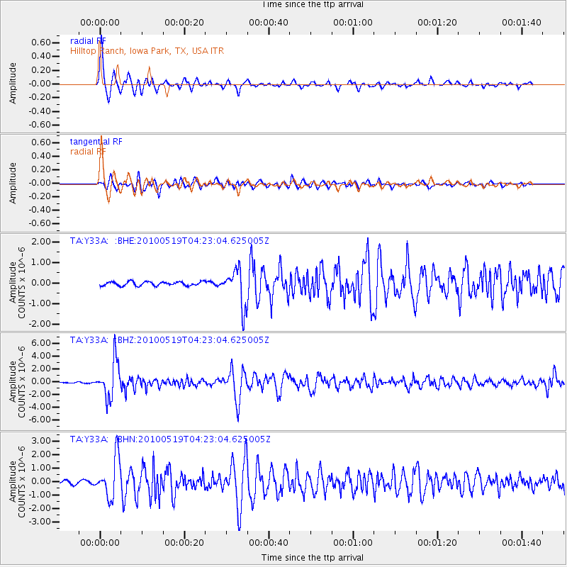
Signal To Noise
| Channel | StoN | STA | LTA |
| TA:Y33A: :BHZ:20100519T04:23:04.625005Z | 35.870495 | 2.9203948E-6 | 8.141495E-8 |
| TA:Y33A: :BHN:20100519T04:23:04.625005Z | 10.953442 | 1.5301829E-6 | 1.3969881E-7 |
| TA:Y33A: :BHE:20100519T04:23:04.625005Z | 9.62306 | 9.277627E-7 | 9.641036E-8 |
| Arrivals |
| Ps | 6.9 SECOND |
| PpPs | 26 SECOND |
| PsPs/PpSs | 33 SECOND |


