You are here: Home > Network List > CM - Red Sismologica Nacional de Columbia Stations List
> Station SMAR Santa Marta, Magdalena, Colombia > Earthquake Result Viewer
SMAR Santa Marta, Magdalena, Colombia - Earthquake Result Viewer
| Earthquake location: |
Gulf Of California |
| Earthquake latitude/longitude: |
23.2/-108.3 |
| Earthquake time(UTC): |
2023/06/18 (169) 20:30:30 GMT |
| Earthquake Depth: |
33 km |
| Earthquake Magnitude: |
6.6 Mi |
| Earthquake Catalog/Contributor: |
NEIC PDE/at |
|
| Network: |
CM Red Sismologica Nacional de Columbia |
| Station: |
SMAR Santa Marta, Magdalena, Colombia |
| Lat/Lon: |
11.16 N/74.22 W |
| Elevation: |
122 m |
|
| Distance: |
34.6 deg |
| Az: |
104.422 deg |
| Baz: |
294.762 deg |
| Ray Param: |
0.07761178 |
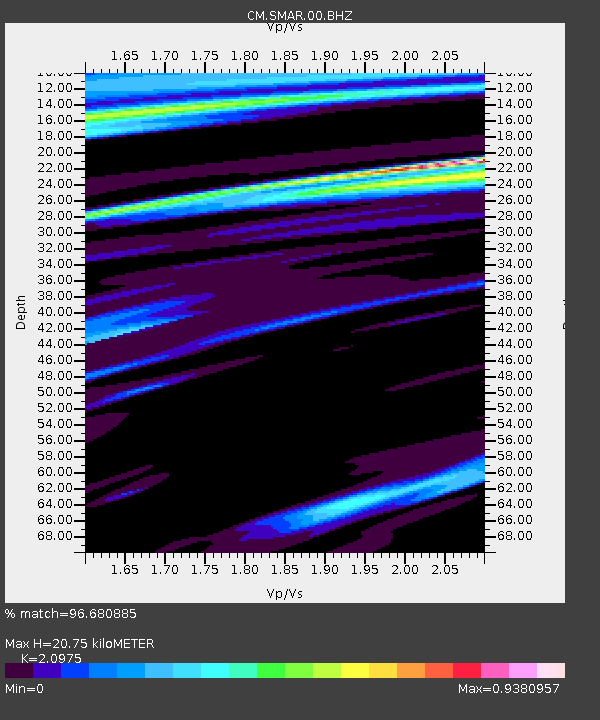
| Estimated Moho Depth: |
20.75 km |
| Estimated Crust Vp/Vs: |
2.10 |
| Assumed Crust Vp: |
5.129 km/s |
| Estimated Crust Vs: |
2.445 km/s |
| Estimated Crust Poisson's Ratio: |
0.35 |
|
| Radial Match: |
96.680885 % |
| Radial Bump: |
292 |
| Transverse Match: |
84.12037 % |
| Transverse Bump: |
400 |
| SOD ConfigId: |
30536071 |
| Insert Time: |
2023-07-02 20:39:49.152 +0000 |
| GWidth: |
2.5 |
| Max Bumps: |
400 |
| Tol: |
0.001 |
|

Signal To Noise
| Channel | StoN | STA | LTA |
| CM:SMAR:00:BHZ:20230618T20:36:45.419006Z | 10.043779 | 1.2187066E-6 | 1.2133945E-7 |
| CM:SMAR:00:BHN:20230618T20:36:45.419006Z | 3.9662757 | 4.0805E-7 | 1.0287989E-7 |
| CM:SMAR:00:BHE:20230618T20:36:45.419006Z | 5.4439135 | 6.4793255E-7 | 1.1901963E-7 |
| Arrivals |
| Ps | 4.6 SECOND |
| PpPs | 12 SECOND |
| PsPs/PpSs | 17 SECOND |


