You are here: Home > Network List > CN - Canadian National Seismograph Network Stations List
> Station INK INUVIK, NT > Earthquake Result Viewer
INK INUVIK, NT - Earthquake Result Viewer
| Earthquake location: |
Gulf Of California |
| Earthquake latitude/longitude: |
23.2/-108.3 |
| Earthquake time(UTC): |
2023/06/18 (169) 20:30:30 GMT |
| Earthquake Depth: |
33 km |
| Earthquake Magnitude: |
6.6 Mi |
| Earthquake Catalog/Contributor: |
NEIC PDE/at |
|
| Network: |
CN Canadian National Seismograph Network |
| Station: |
INK INUVIK, NT |
| Lat/Lon: |
68.31 N/133.53 W |
| Elevation: |
44 m |
|
| Distance: |
47.7 deg |
| Az: |
347.629 deg |
| Baz: |
147.98 deg |
| Ray Param: |
0.06978239 |
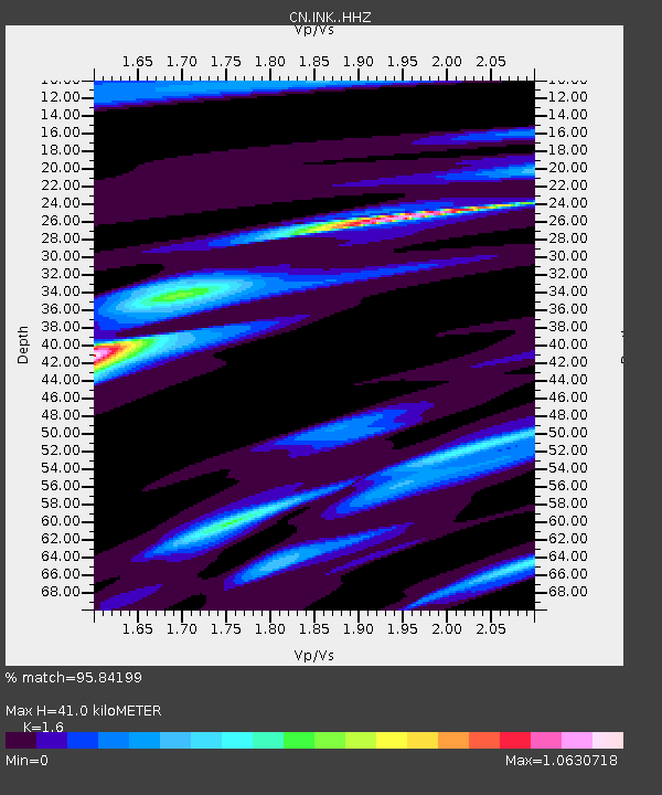
| Estimated Moho Depth: |
41.0 km |
| Estimated Crust Vp/Vs: |
1.60 |
| Assumed Crust Vp: |
6.171 km/s |
| Estimated Crust Vs: |
3.857 km/s |
| Estimated Crust Poisson's Ratio: |
0.18 |
|
| Radial Match: |
95.84199 % |
| Radial Bump: |
223 |
| Transverse Match: |
85.36529 % |
| Transverse Bump: |
388 |
| SOD ConfigId: |
30536071 |
| Insert Time: |
2023-07-02 20:41:01.439 +0000 |
| GWidth: |
2.5 |
| Max Bumps: |
400 |
| Tol: |
0.001 |
|
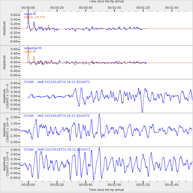
Signal To Noise
| Channel | StoN | STA | LTA |
| CN:INK: :HHZ:20230618T20:38:32.820007Z | 7.5141625 | 6.9541795E-7 | 9.254763E-8 |
| CN:INK: :HHN:20230618T20:38:32.820007Z | 7.721132 | 3.9888278E-7 | 5.166118E-8 |
| CN:INK: :HHE:20230618T20:38:32.820007Z | 4.7258654 | 2.7092307E-7 | 5.732772E-8 |
| Arrivals |
| Ps | 4.2 SECOND |
| PpPs | 16 SECOND |
| PsPs/PpSs | 20 SECOND |


