You are here: Home > Network List > TA - USArray Transportable Network (new EarthScope stations) Stations List
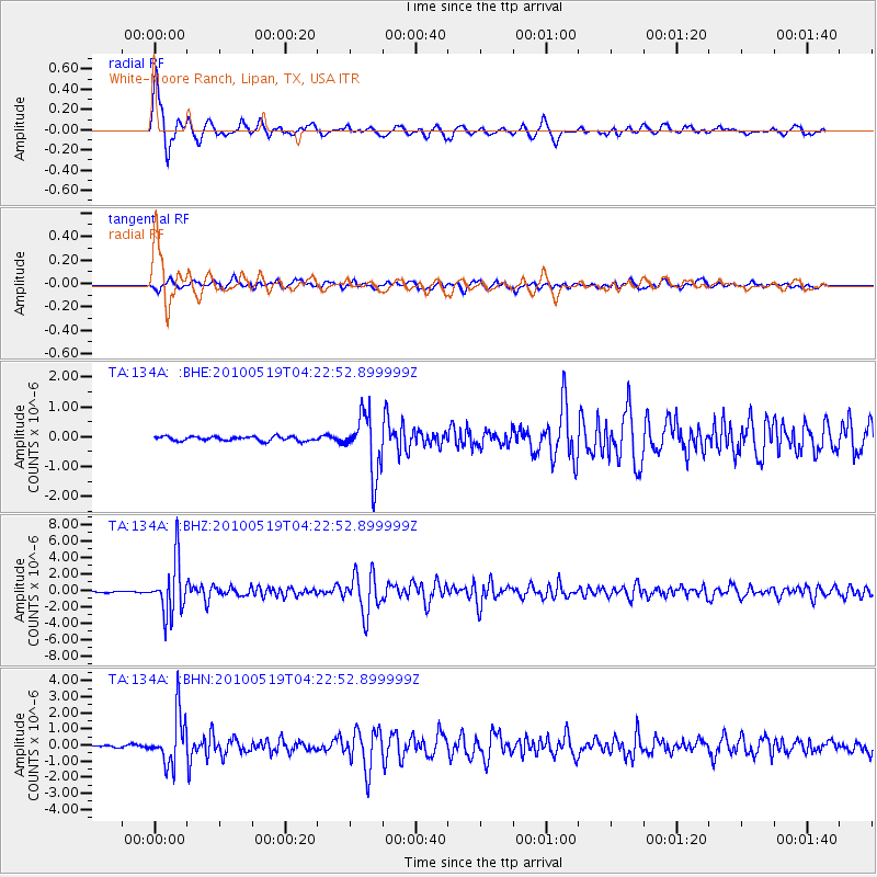
> Station 134A White-Moore Ranch, Lipan, TX, USA > Earthquake Result Viewer
134A White-Moore Ranch, Lipan, TX, USA - Earthquake Result Viewer
| Earthquake location: |
Northern Peru |
| Earthquake latitude/longitude: |
-5.1/-77.5 |
| Earthquake time(UTC): |
2010/05/19 (139) 04:15:44 GMT |
| Earthquake Depth: |
140 km |
| Earthquake Magnitude: |
6.0 MB, 6.0 MW, 6.0 MW |
| Earthquake Catalog/Contributor: |
WHDF/NEIC |
|
| Network: |
TA USArray Transportable Network (new EarthScope stations) |
| Station: |
134A White-Moore Ranch, Lipan, TX, USA |
| Lat/Lon: |
32.57 N/98.08 W |
| Elevation: |
297 m |
|
| Distance: |
42.2 deg |
| Az: |
333.839 deg |
| Baz: |
148.658 deg |
| Ray Param: |
0.07280268 |
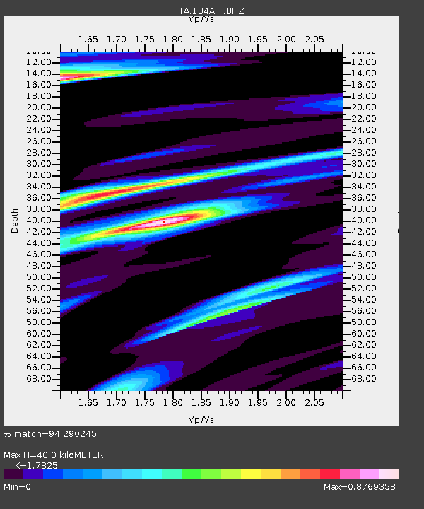
| Estimated Moho Depth: |
40.0 km |
| Estimated Crust Vp/Vs: |
1.78 |
| Assumed Crust Vp: |
6.426 km/s |
| Estimated Crust Vs: |
3.605 km/s |
| Estimated Crust Poisson's Ratio: |
0.27 |
|
| Radial Match: |
94.290245 % |
| Radial Bump: |
349 |
| Transverse Match: |
85.524925 % |
| Transverse Bump: |
400 |
| SOD ConfigId: |
314592 |
| Insert Time: |
2010-09-04 07:45:43.271 +0000 |
| GWidth: |
2.5 |
| Max Bumps: |
400 |
| Tol: |
0.001 |
|
Signal To Noise
| Channel | StoN | STA | LTA |
| TA:134A: :BHZ:20100519T04:22:52.899999Z | 34.223465 | 3.276477E-6 | 9.573773E-8 |
| TA:134A: :BHN:20100519T04:22:52.899999Z | 19.225096 | 1.5571927E-6 | 8.099792E-8 |
| TA:134A: :BHE:20100519T04:22:52.899999Z | 14.067632 | 1.0042736E-6 | 7.138896E-8 |
| Arrivals |
| Ps | 5.2 SECOND |
| PpPs | 16 SECOND |
| PsPs/PpSs | 21 SECOND |


