You are here: Home > Network List > G - GEOSCOPE Stations List
> Station FDFM Morne la Rosette, Martinique, France > Earthquake Result Viewer
FDFM Morne la Rosette, Martinique, France - Earthquake Result Viewer
| Earthquake location: |
Gulf Of California |
| Earthquake latitude/longitude: |
23.2/-108.3 |
| Earthquake time(UTC): |
2023/06/18 (169) 20:30:30 GMT |
| Earthquake Depth: |
33 km |
| Earthquake Magnitude: |
6.6 Mi |
| Earthquake Catalog/Contributor: |
NEIC PDE/at |
|
| Network: |
G GEOSCOPE |
| Station: |
FDFM Morne la Rosette, Martinique, France |
| Lat/Lon: |
14.73 N/61.16 W |
| Elevation: |
320 m |
|
| Distance: |
45.2 deg |
| Az: |
92.038 deg |
| Baz: |
288.128 deg |
| Ray Param: |
0.071369655 |
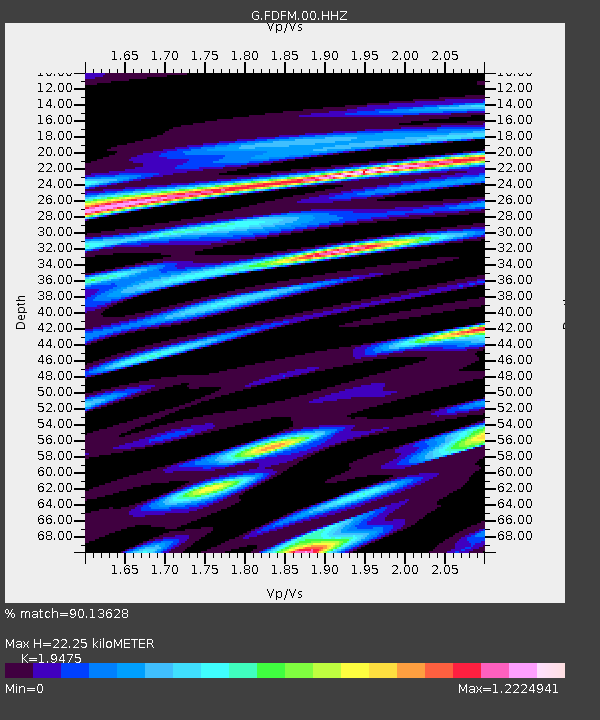
| Estimated Moho Depth: |
22.25 km |
| Estimated Crust Vp/Vs: |
1.95 |
| Assumed Crust Vp: |
5.88 km/s |
| Estimated Crust Vs: |
3.019 km/s |
| Estimated Crust Poisson's Ratio: |
0.32 |
|
| Radial Match: |
90.13628 % |
| Radial Bump: |
400 |
| Transverse Match: |
68.70319 % |
| Transverse Bump: |
400 |
| SOD ConfigId: |
30536071 |
| Insert Time: |
2023-07-02 20:42:58.495 +0000 |
| GWidth: |
2.5 |
| Max Bumps: |
400 |
| Tol: |
0.001 |
|

Signal To Noise
| Channel | StoN | STA | LTA |
| G:FDFM:00:HHZ:20230618T20:38:13.350006Z | 7.0115657 | 1.7315857E-6 | 2.4696135E-7 |
| G:FDFM:00:HHN:20230618T20:38:13.350006Z | 1.5919038 | 4.6654307E-7 | 2.9307242E-7 |
| G:FDFM:00:HHE:20230618T20:38:13.350006Z | 3.3297951 | 1.3049362E-6 | 3.9189683E-7 |
| Arrivals |
| Ps | 3.8 SECOND |
| PpPs | 11 SECOND |
| PsPs/PpSs | 14 SECOND |


