You are here: Home > Network List > LD - Lamont-Doherty Cooperative Seismographic Network Stations List
> Station GEDE Greenville, DE, USA > Earthquake Result Viewer
GEDE Greenville, DE, USA - Earthquake Result Viewer
| Earthquake location: |
Gulf Of California |
| Earthquake latitude/longitude: |
23.2/-108.3 |
| Earthquake time(UTC): |
2023/06/18 (169) 20:30:30 GMT |
| Earthquake Depth: |
33 km |
| Earthquake Magnitude: |
6.6 Mi |
| Earthquake Catalog/Contributor: |
NEIC PDE/at |
|
| Network: |
LD Lamont-Doherty Cooperative Seismographic Network |
| Station: |
GEDE Greenville, DE, USA |
| Lat/Lon: |
39.81 N/75.64 W |
| Elevation: |
105 m |
|
| Distance: |
32.2 deg |
| Az: |
51.325 deg |
| Baz: |
248.837 deg |
| Ray Param: |
0.078730084 |
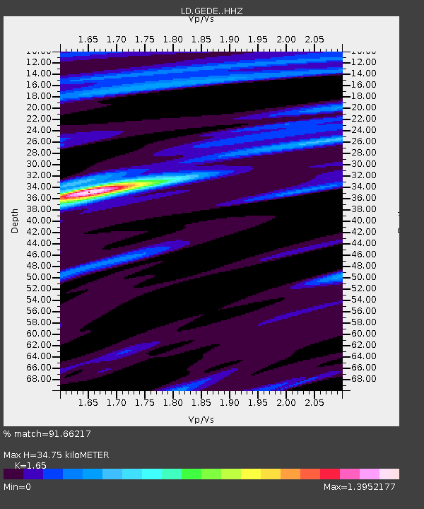
| Estimated Moho Depth: |
34.75 km |
| Estimated Crust Vp/Vs: |
1.65 |
| Assumed Crust Vp: |
6.287 km/s |
| Estimated Crust Vs: |
3.811 km/s |
| Estimated Crust Poisson's Ratio: |
0.21 |
|
| Radial Match: |
91.66217 % |
| Radial Bump: |
283 |
| Transverse Match: |
74.18042 % |
| Transverse Bump: |
400 |
| SOD ConfigId: |
30536071 |
| Insert Time: |
2023-07-02 20:45:07.831 +0000 |
| GWidth: |
2.5 |
| Max Bumps: |
400 |
| Tol: |
0.001 |
|

Signal To Noise
| Channel | StoN | STA | LTA |
| LD:GEDE: :HHZ:20230618T20:36:24.417999Z | 5.9037614 | 8.846368E-7 | 1.498429E-7 |
| LD:GEDE: :HHN:20230618T20:36:24.417999Z | 2.0246227 | 2.577986E-7 | 1.2733167E-7 |
| LD:GEDE: :HHE:20230618T20:36:24.417999Z | 6.1728525 | 5.409955E-7 | 8.7641084E-8 |
| Arrivals |
| Ps | 3.9 SECOND |
| PpPs | 14 SECOND |
| PsPs/PpSs | 17 SECOND |


