You are here: Home > Network List > TA - USArray Transportable Network (new EarthScope stations) Stations List
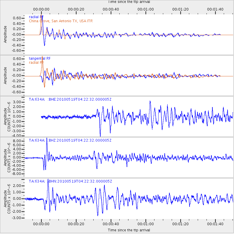
> Station 634A China Grove, San Antonio TX, USA > Earthquake Result Viewer
634A China Grove, San Antonio TX, USA - Earthquake Result Viewer
| Earthquake location: |
Northern Peru |
| Earthquake latitude/longitude: |
-5.1/-77.5 |
| Earthquake time(UTC): |
2010/05/19 (139) 04:15:44 GMT |
| Earthquake Depth: |
140 km |
| Earthquake Magnitude: |
6.0 MB, 6.0 MW, 6.0 MW |
| Earthquake Catalog/Contributor: |
WHDF/NEIC |
|
| Network: |
TA USArray Transportable Network (new EarthScope stations) |
| Station: |
634A China Grove, San Antonio TX, USA |
| Lat/Lon: |
29.38 N/98.35 W |
| Elevation: |
188 m |
|
| Distance: |
39.7 deg |
| Az: |
330.93 deg |
| Baz: |
146.32 deg |
| Ray Param: |
0.07435616 |
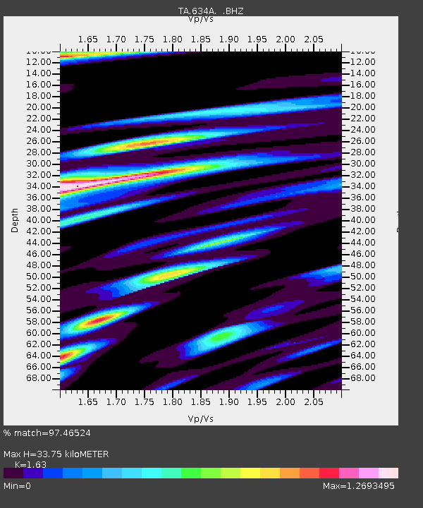
| Estimated Moho Depth: |
33.75 km |
| Estimated Crust Vp/Vs: |
1.63 |
| Assumed Crust Vp: |
6.347 km/s |
| Estimated Crust Vs: |
3.894 km/s |
| Estimated Crust Poisson's Ratio: |
0.20 |
|
| Radial Match: |
97.46524 % |
| Radial Bump: |
351 |
| Transverse Match: |
91.994736 % |
| Transverse Bump: |
400 |
| SOD ConfigId: |
314592 |
| Insert Time: |
2010-09-04 07:46:21.849 +0000 |
| GWidth: |
2.5 |
| Max Bumps: |
400 |
| Tol: |
0.001 |
|
Signal To Noise
| Channel | StoN | STA | LTA |
| TA:634A: :BHZ:20100519T04:22:32.000005Z | 30.244837 | 3.1049515E-6 | 1.0266055E-7 |
| TA:634A: :BHN:20100519T04:22:32.000005Z | 13.759704 | 1.1136832E-6 | 8.093802E-8 |
| TA:634A: :BHE:20100519T04:22:32.000005Z | 7.868224 | 1.2442039E-6 | 1.5813019E-7 |
| Arrivals |
| Ps | 3.6 SECOND |
| PpPs | 13 SECOND |
| PsPs/PpSs | 17 SECOND |


