You are here: Home > Network List > US - United States National Seismic Network Stations List
> Station CBKS Cedar Bluff, Kansas, USA > Earthquake Result Viewer
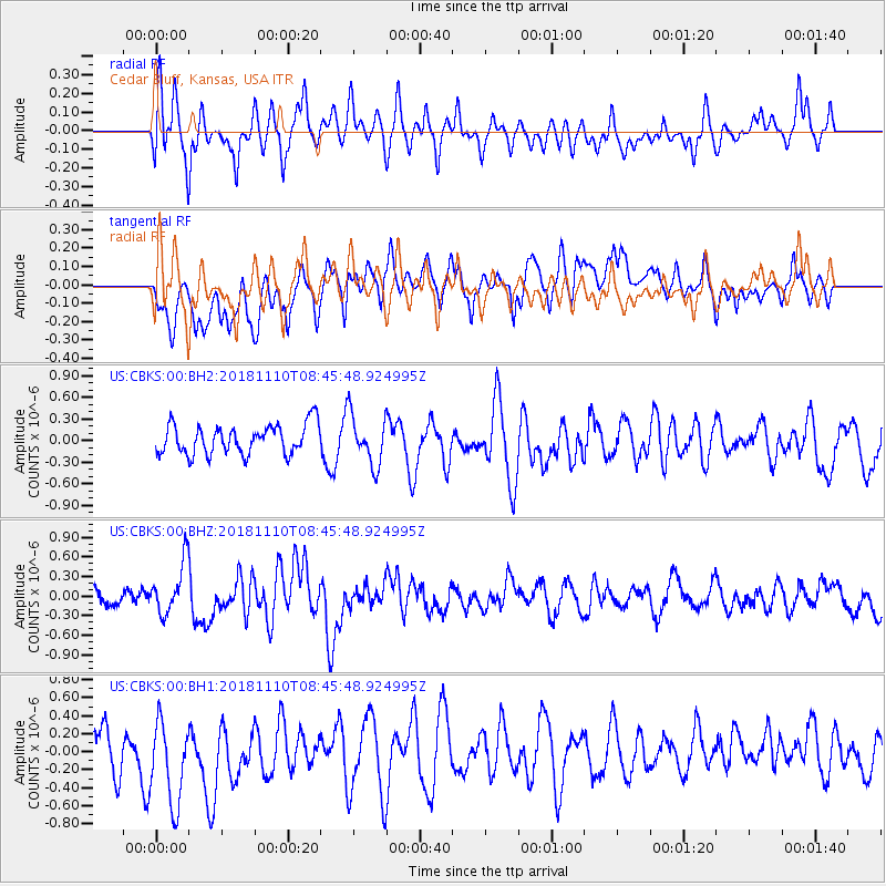
CBKS Cedar Bluff, Kansas, USA - Earthquake Result Viewer
*The percent match for this event was below the threshold and hence no stack was calculated.
| Earthquake location: |
Tonga Islands |
| Earthquake latitude/longitude: |
-20.5/-173.8 |
| Earthquake time(UTC): |
2018/11/10 (314) 08:33:16 GMT |
| Earthquake Depth: |
10 km |
| Earthquake Magnitude: |
6.2 Mww |
| Earthquake Catalog/Contributor: |
NEIC PDE/us |
|
| Network: |
US United States National Seismic Network |
| Station: |
CBKS Cedar Bluff, Kansas, USA |
| Lat/Lon: |
38.81 N/99.74 W |
| Elevation: |
677 m |
|
| Distance: |
91.0 deg |
| Az: |
48.71 deg |
| Baz: |
244.345 deg |
| Ray Param: |
$rayparam |
*The percent match for this event was below the threshold and hence was not used in the summary stack. |
|
| Radial Match: |
64.763916 % |
| Radial Bump: |
400 |
| Transverse Match: |
50.38614 % |
| Transverse Bump: |
400 |
| SOD ConfigId: |
3131071 |
| Insert Time: |
2018-11-24 08:44:53.772 +0000 |
| GWidth: |
2.5 |
| Max Bumps: |
400 |
| Tol: |
0.001 |
|
Signal To Noise
| Channel | StoN | STA | LTA |
| US:CBKS:00:BHZ:20181110T08:45:48.924995Z | 1.8399137 | 3.9060248E-7 | 2.1229391E-7 |
| US:CBKS:00:BH1:20181110T08:45:48.924995Z | 1.8564239 | 5.0200134E-7 | 2.7041312E-7 |
| US:CBKS:00:BH2:20181110T08:45:48.924995Z | 1.6847154 | 3.4698252E-7 | 2.0595913E-7 |
| Arrivals |
| Ps | |
| PpPs | |
| PsPs/PpSs | |


