You are here: Home > Network List > WI - West Indies IPGP Network Stations List
> Station BIM Morne Bigot, Anses d'Arlets, Martinique > Earthquake Result Viewer
BIM Morne Bigot, Anses d'Arlets, Martinique - Earthquake Result Viewer
| Earthquake location: |
Gulf Of California |
| Earthquake latitude/longitude: |
23.2/-108.3 |
| Earthquake time(UTC): |
2023/06/18 (169) 20:30:30 GMT |
| Earthquake Depth: |
33 km |
| Earthquake Magnitude: |
6.6 Mi |
| Earthquake Catalog/Contributor: |
NEIC PDE/at |
|
| Network: |
WI West Indies IPGP Network |
| Station: |
BIM Morne Bigot, Anses d'Arlets, Martinique |
| Lat/Lon: |
14.52 N/61.07 W |
| Elevation: |
391 m |
|
| Distance: |
45.4 deg |
| Az: |
92.286 deg |
| Baz: |
288.326 deg |
| Ray Param: |
0.071267135 |
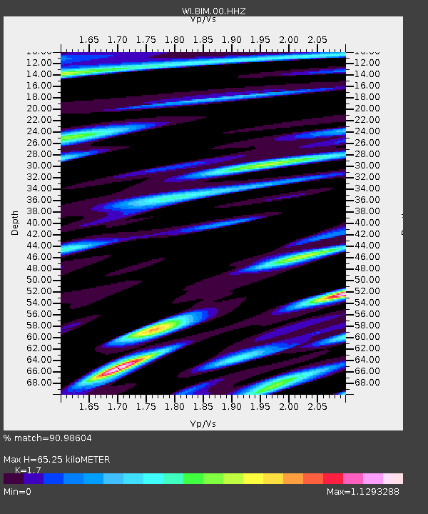
| Estimated Moho Depth: |
65.25 km |
| Estimated Crust Vp/Vs: |
1.70 |
| Assumed Crust Vp: |
5.88 km/s |
| Estimated Crust Vs: |
3.459 km/s |
| Estimated Crust Poisson's Ratio: |
0.24 |
|
| Radial Match: |
90.98604 % |
| Radial Bump: |
400 |
| Transverse Match: |
76.308464 % |
| Transverse Bump: |
400 |
| SOD ConfigId: |
30536071 |
| Insert Time: |
2023-07-02 20:49:21.847 +0000 |
| GWidth: |
2.5 |
| Max Bumps: |
400 |
| Tol: |
0.001 |
|
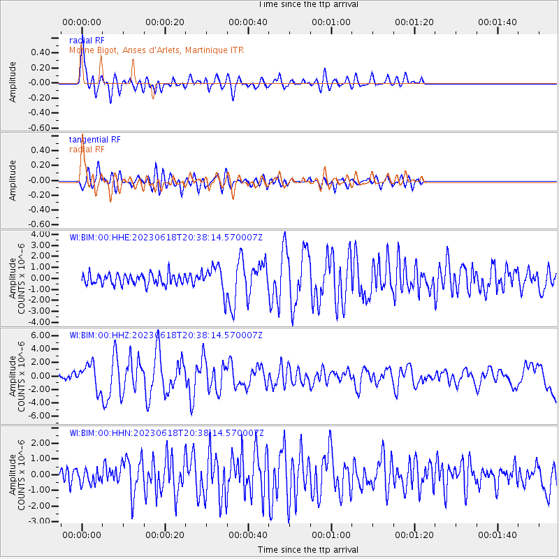
Signal To Noise
| Channel | StoN | STA | LTA |
| WI:BIM:00:HHZ:20230618T20:38:14.570007Z | 7.19781 | 1.8850199E-6 | 2.6188798E-7 |
| WI:BIM:00:HHN:20230618T20:38:14.570007Z | 1.0052935 | 4.383113E-7 | 4.3600332E-7 |
| WI:BIM:00:HHE:20230618T20:38:14.570007Z | 2.5989137 | 1.2436477E-6 | 4.78526E-7 |
| Arrivals |
| Ps | 8.2 SECOND |
| PpPs | 28 SECOND |
| PsPs/PpSs | 37 SECOND |


