You are here: Home > Network List > XL17 - McGill Dawson-Septimus Induced Seismicity Study () Stations List
> Station MG03 Z > Earthquake Result Viewer
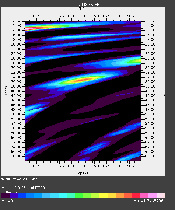
MG03 Z - Earthquake Result Viewer
| Earthquake location: |
Gulf Of California |
| Earthquake latitude/longitude: |
23.2/-108.3 |
| Earthquake time(UTC): |
2023/06/18 (169) 20:30:30 GMT |
| Earthquake Depth: |
33 km |
| Earthquake Magnitude: |
6.6 Mi |
| Earthquake Catalog/Contributor: |
NEIC PDE/at |
|
| Network: |
XL McGill Dawson-Septimus Induced Seismicity Study () |
| Station: |
MG03 Z |
| Lat/Lon: |
55.91 N/120.44 W |
| Elevation: |
697 m |
|
| Distance: |
33.9 deg |
| Az: |
347.736 deg |
| Baz: |
159.689 deg |
| Ray Param: |
0.07796181 |
| Estimated Moho Depth: |
13.25 km |
| Estimated Crust Vp/Vs: |
1.60 |
| Assumed Crust Vp: |
6.303 km/s |
| Estimated Crust Vs: |
3.939 km/s |
| Estimated Crust Poisson's Ratio: |
0.18 |
|
| Radial Match: |
92.82665 % |
| Radial Bump: |
348 |
| Transverse Match: |
82.20824 % |
| Transverse Bump: |
379 |
| SOD ConfigId: |
30536071 |
| Insert Time: |
2023-07-02 20:50:05.456 +0000 |
| GWidth: |
2.5 |
| Max Bumps: |
400 |
| Tol: |
0.001 |
|

Signal To Noise
| Channel | StoN | STA | LTA |
| XL:MG03: :HHZ:20230618T20:36:39.279999Z | 7.101345 | 1.2536569E-6 | 1.7653795E-7 |
| XL:MG03: :HHN:20230618T20:36:39.279999Z | 1.7803407 | 5.2234384E-7 | 2.9339546E-7 |
| XL:MG03: :HHE:20230618T20:36:39.279999Z | 2.354201 | 4.5889675E-7 | 1.9492674E-7 |
| Arrivals |
| Ps | 1.4 SECOND |
| PpPs | 5.0 SECOND |
| PsPs/PpSs | 6.4 SECOND |


