You are here: Home > Network List > US - United States National Seismic Network Stations List
> Station HAWA Hanford, Washington, USA > Earthquake Result Viewer
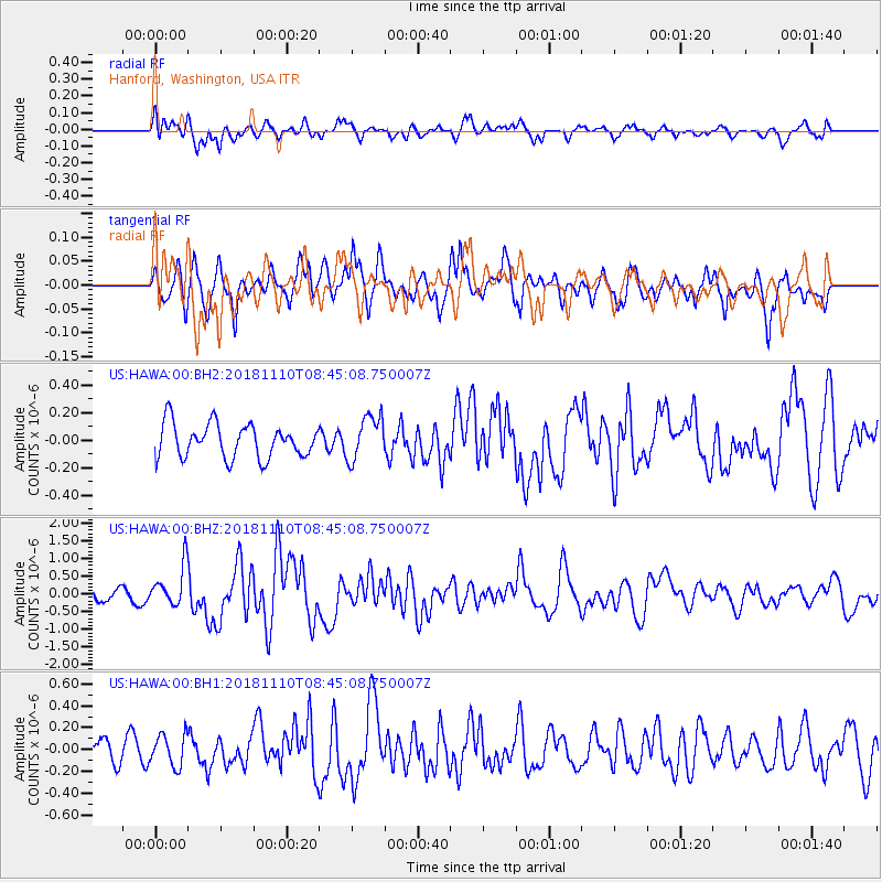
HAWA Hanford, Washington, USA - Earthquake Result Viewer
*The percent match for this event was below the threshold and hence no stack was calculated.
| Earthquake location: |
Tonga Islands |
| Earthquake latitude/longitude: |
-20.5/-173.8 |
| Earthquake time(UTC): |
2018/11/10 (314) 08:33:16 GMT |
| Earthquake Depth: |
10 km |
| Earthquake Magnitude: |
6.2 Mww |
| Earthquake Catalog/Contributor: |
NEIC PDE/us |
|
| Network: |
US United States National Seismic Network |
| Station: |
HAWA Hanford, Washington, USA |
| Lat/Lon: |
46.39 N/119.53 W |
| Elevation: |
364 m |
|
| Distance: |
82.7 deg |
| Az: |
34.511 deg |
| Baz: |
230.102 deg |
| Ray Param: |
$rayparam |
*The percent match for this event was below the threshold and hence was not used in the summary stack. |
|
| Radial Match: |
71.0235 % |
| Radial Bump: |
400 |
| Transverse Match: |
67.51157 % |
| Transverse Bump: |
398 |
| SOD ConfigId: |
3131071 |
| Insert Time: |
2018-11-24 08:45:04.369 +0000 |
| GWidth: |
2.5 |
| Max Bumps: |
400 |
| Tol: |
0.001 |
|
Signal To Noise
| Channel | StoN | STA | LTA |
| US:HAWA:00:BHZ:20181110T08:45:08.750007Z | 2.5977328 | 5.597935E-7 | 2.154931E-7 |
| US:HAWA:00:BH1:20181110T08:45:08.750007Z | 0.9919263 | 1.4455294E-7 | 1.4572952E-7 |
| US:HAWA:00:BH2:20181110T08:45:08.750007Z | 1.3342971 | 1.6228404E-7 | 1.2162512E-7 |
| Arrivals |
| Ps | |
| PpPs | |
| PsPs/PpSs | |


