You are here: Home > Network List > UU - University of Utah Regional Network Stations List
> Station FOR1 Milford Southwest, UT, USA > Earthquake Result Viewer
FOR1 Milford Southwest, UT, USA - Earthquake Result Viewer
| Earthquake location: |
Tonga Islands |
| Earthquake latitude/longitude: |
-20.5/-173.8 |
| Earthquake time(UTC): |
2018/11/10 (314) 08:33:16 GMT |
| Earthquake Depth: |
10 km |
| Earthquake Magnitude: |
6.2 Mww |
| Earthquake Catalog/Contributor: |
NEIC PDE/us |
|
| Network: |
UU University of Utah Regional Network |
| Station: |
FOR1 Milford Southwest, UT, USA |
| Lat/Lon: |
38.37 N/113.09 W |
| Elevation: |
1642 m |
|
| Distance: |
81.7 deg |
| Az: |
43.864 deg |
| Baz: |
235.713 deg |
| Ray Param: |
0.047415927 |
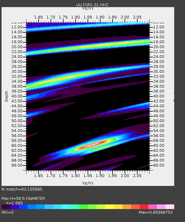
| Estimated Moho Depth: |
59.5 km |
| Estimated Crust Vp/Vs: |
1.87 |
| Assumed Crust Vp: |
6.276 km/s |
| Estimated Crust Vs: |
3.365 km/s |
| Estimated Crust Poisson's Ratio: |
0.30 |
|
| Radial Match: |
83.105865 % |
| Radial Bump: |
342 |
| Transverse Match: |
72.16678 % |
| Transverse Bump: |
400 |
| SOD ConfigId: |
3131071 |
| Insert Time: |
2018-11-24 08:45:34.978 +0000 |
| GWidth: |
2.5 |
| Max Bumps: |
400 |
| Tol: |
0.001 |
|

Signal To Noise
| Channel | StoN | STA | LTA |
| UU:FOR1:01:HHZ:20181110T08:45:03.390022Z | 0.7579271 | 2.1002504E-9 | 2.7710454E-9 |
| UU:FOR1:01:HHN:20181110T08:45:03.390022Z | 1.2028375 | 4.7279314E-9 | 3.9306487E-9 |
| UU:FOR1:01:HHE:20181110T08:45:03.390022Z | 0.8304727 | 2.9450224E-9 | 3.5462E-9 |
| Arrivals |
| Ps | 8.4 SECOND |
| PpPs | 27 SECOND |
| PsPs/PpSs | 35 SECOND |


