You are here: Home > Network List > TA - USArray Transportable Network (new EarthScope stations) Stations List
> Station W36A Wetumka, OK, USA > Earthquake Result Viewer
W36A Wetumka, OK, USA - Earthquake Result Viewer
| Earthquake location: |
Northern Peru |
| Earthquake latitude/longitude: |
-5.1/-77.5 |
| Earthquake time(UTC): |
2010/05/19 (139) 04:15:44 GMT |
| Earthquake Depth: |
140 km |
| Earthquake Magnitude: |
6.0 MB, 6.0 MW, 6.0 MW |
| Earthquake Catalog/Contributor: |
WHDF/NEIC |
|
| Network: |
TA USArray Transportable Network (new EarthScope stations) |
| Station: |
W36A Wetumka, OK, USA |
| Lat/Lon: |
35.14 N/96.23 W |
| Elevation: |
251 m |
|
| Distance: |
43.7 deg |
| Az: |
337.656 deg |
| Baz: |
152.479 deg |
| Ray Param: |
0.0718759 |
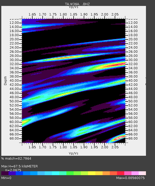
| Estimated Moho Depth: |
67.5 km |
| Estimated Crust Vp/Vs: |
2.07 |
| Assumed Crust Vp: |
6.426 km/s |
| Estimated Crust Vs: |
3.108 km/s |
| Estimated Crust Poisson's Ratio: |
0.35 |
|
| Radial Match: |
82.7964 % |
| Radial Bump: |
392 |
| Transverse Match: |
77.903366 % |
| Transverse Bump: |
400 |
| SOD ConfigId: |
314592 |
| Insert Time: |
2010-09-04 07:49:19.361 +0000 |
| GWidth: |
2.5 |
| Max Bumps: |
400 |
| Tol: |
0.001 |
|
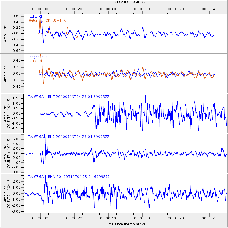
Signal To Noise
| Channel | StoN | STA | LTA |
| TA:W36A: :BHZ:20100519T04:23:04.699987Z | 22.906328 | 2.9588211E-6 | 1.2917047E-7 |
| TA:W36A: :BHN:20100519T04:23:04.699987Z | 6.288151 | 1.3487709E-6 | 2.1449405E-7 |
| TA:W36A: :BHE:20100519T04:23:04.699987Z | 5.862692 | 7.27116E-7 | 1.2402425E-7 |
| Arrivals |
| Ps | 12 SECOND |
| PpPs | 30 SECOND |
| PsPs/PpSs | 42 SECOND |


