You are here: Home > Network List > GO - National Seismic Network of Georgia Stations List
> Station MINA Georgia, Mina > Earthquake Result Viewer
MINA Georgia, Mina - Earthquake Result Viewer
| Earthquake location: |
Near South Coast Of Myanmar |
| Earthquake latitude/longitude: |
15.3/96.3 |
| Earthquake time(UTC): |
2023/06/19 (170) 01:40:23 GMT |
| Earthquake Depth: |
5.3 km |
| Earthquake Magnitude: |
5.4 Mww |
| Earthquake Catalog/Contributor: |
NEIC PDE/us |
|
| Network: |
GO National Seismic Network of Georgia |
| Station: |
MINA Georgia, Mina |
| Lat/Lon: |
41.60 N/43.02 E |
| Elevation: |
1568 m |
|
| Distance: |
52.7 deg |
| Az: |
310.895 deg |
| Baz: |
103.441 deg |
| Ray Param: |
0.06659632 |
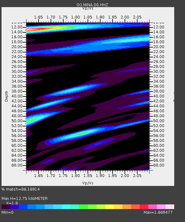
| Estimated Moho Depth: |
12.75 km |
| Estimated Crust Vp/Vs: |
1.60 |
| Assumed Crust Vp: |
6.419 km/s |
| Estimated Crust Vs: |
4.012 km/s |
| Estimated Crust Poisson's Ratio: |
0.18 |
|
| Radial Match: |
86.16914 % |
| Radial Bump: |
388 |
| Transverse Match: |
72.66292 % |
| Transverse Bump: |
400 |
| SOD ConfigId: |
30536071 |
| Insert Time: |
2023-07-03 01:50:34.746 +0000 |
| GWidth: |
2.5 |
| Max Bumps: |
400 |
| Tol: |
0.001 |
|

Signal To Noise
| Channel | StoN | STA | LTA |
| GO:MINA:00:HHZ:20230619T01:49:07.789987Z | 4.4460883 | 3.4609408E-7 | 7.784237E-8 |
| GO:MINA:00:HHN:20230619T01:49:07.789987Z | 1.4972787 | 5.5382802E-8 | 3.6988972E-8 |
| GO:MINA:00:HHE:20230619T01:49:07.789987Z | 3.1406543 | 1.10257496E-7 | 3.5106538E-8 |
| Arrivals |
| Ps | 1.3 SECOND |
| PpPs | 4.9 SECOND |
| PsPs/PpSs | 6.1 SECOND |


