You are here: Home > Network List > TA - USArray Transportable Network (new EarthScope stations) Stations List
> Station X36A Centrahoma, OK, USA > Earthquake Result Viewer
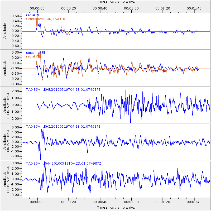
X36A Centrahoma, OK, USA - Earthquake Result Viewer
*The percent match for this event was below the threshold and hence no stack was calculated.
| Earthquake location: |
Northern Peru |
| Earthquake latitude/longitude: |
-5.1/-77.5 |
| Earthquake time(UTC): |
2010/05/19 (139) 04:15:44 GMT |
| Earthquake Depth: |
140 km |
| Earthquake Magnitude: |
6.0 MB, 6.0 MW, 6.0 MW |
| Earthquake Catalog/Contributor: |
WHDF/NEIC |
|
| Network: |
TA USArray Transportable Network (new EarthScope stations) |
| Station: |
X36A Centrahoma, OK, USA |
| Lat/Lon: |
34.57 N/96.35 W |
| Elevation: |
211 m |
|
| Distance: |
43.2 deg |
| Az: |
337.139 deg |
| Baz: |
152.033 deg |
| Ray Param: |
$rayparam |
*The percent match for this event was below the threshold and hence was not used in the summary stack. |
|
| Radial Match: |
79.9819 % |
| Radial Bump: |
400 |
| Transverse Match: |
72.069466 % |
| Transverse Bump: |
400 |
| SOD ConfigId: |
314592 |
| Insert Time: |
2010-09-04 07:49:43.648 +0000 |
| GWidth: |
2.5 |
| Max Bumps: |
400 |
| Tol: |
0.001 |
|
Signal To Noise
| Channel | StoN | STA | LTA |
| TA:X36A: :BHZ:20100519T04:23:01.074987Z | 15.811948 | 3.0153046E-6 | 1.9069785E-7 |
| TA:X36A: :BHN:20100519T04:23:01.074987Z | 8.339364 | 1.2068799E-6 | 1.4472086E-7 |
| TA:X36A: :BHE:20100519T04:23:01.074987Z | 1.8588234 | 5.026888E-7 | 2.7043387E-7 |
| Arrivals |
| Ps | |
| PpPs | |
| PsPs/PpSs | |


