You are here: Home > Network List > AK - Alaska Regional Network Stations List
> Station HIN Hinchinbrook, AK, USA > Earthquake Result Viewer
HIN Hinchinbrook, AK, USA - Earthquake Result Viewer
| Earthquake location: |
Near N Coast Of New Guinea, P.N.G. |
| Earthquake latitude/longitude: |
-4.5/144.9 |
| Earthquake time(UTC): |
2023/06/19 (170) 11:18:11 GMT |
| Earthquake Depth: |
21 km |
| Earthquake Magnitude: |
5.9 Mww |
| Earthquake Catalog/Contributor: |
NEIC PDE/us |
|
| Network: |
AK Alaska Regional Network |
| Station: |
HIN Hinchinbrook, AK, USA |
| Lat/Lon: |
60.40 N/146.50 W |
| Elevation: |
623 m |
|
| Distance: |
83.5 deg |
| Az: |
27.733 deg |
| Baz: |
249.138 deg |
| Ray Param: |
0.046131533 |
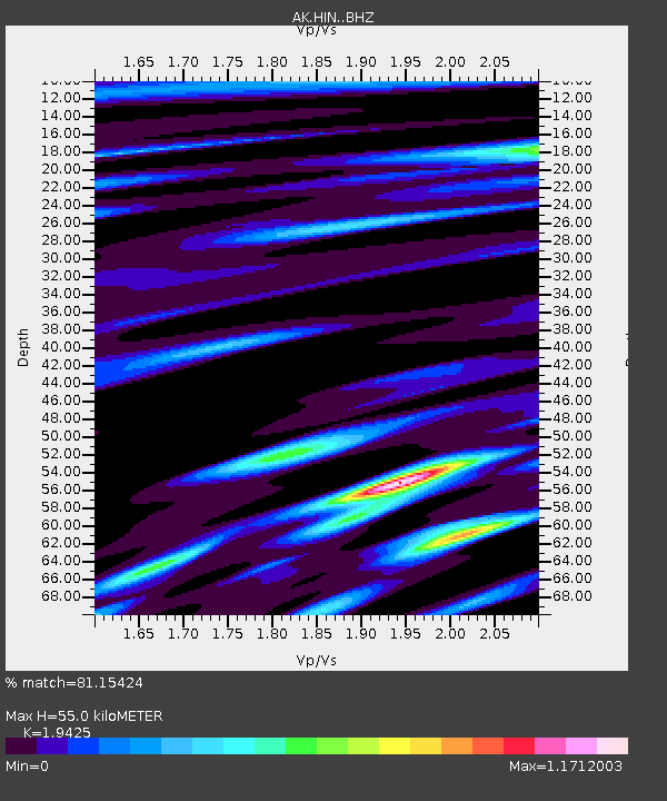
| Estimated Moho Depth: |
55.0 km |
| Estimated Crust Vp/Vs: |
1.94 |
| Assumed Crust Vp: |
6.566 km/s |
| Estimated Crust Vs: |
3.38 km/s |
| Estimated Crust Poisson's Ratio: |
0.32 |
|
| Radial Match: |
81.15424 % |
| Radial Bump: |
400 |
| Transverse Match: |
70.077194 % |
| Transverse Bump: |
400 |
| SOD ConfigId: |
30536071 |
| Insert Time: |
2023-07-03 11:21:24.824 +0000 |
| GWidth: |
2.5 |
| Max Bumps: |
400 |
| Tol: |
0.001 |
|

Signal To Noise
| Channel | StoN | STA | LTA |
| AK:HIN: :BHZ:20230619T11:30:06.627002Z | 5.2513523 | 5.0879675E-7 | 9.688872E-8 |
| AK:HIN: :BHN:20230619T11:30:06.627002Z | 1.1637272 | 1.4348699E-7 | 1.2329951E-7 |
| AK:HIN: :BHE:20230619T11:30:06.627002Z | 1.1537048 | 1.6544942E-7 | 1.4340708E-7 |
| Arrivals |
| Ps | 8.1 SECOND |
| PpPs | 24 SECOND |
| PsPs/PpSs | 32 SECOND |


