You are here: Home > Network List > AG - Arkansas Seismic Network Stations List
> Station U40A Yellville, AR > Earthquake Result Viewer
U40A Yellville, AR - Earthquake Result Viewer

| Earthquake location: |
North Atlantic Ocean |
| Earthquake latitude/longitude: |
15.6/-49.9 |
| Earthquake time(UTC): |
2018/11/11 (315) 14:03:59 GMT |
| Earthquake Depth: |
10 km |
| Earthquake Magnitude: |
6.2 mb |
| Earthquake Catalog/Contributor: |
NEIC PDE/us |
|
| Network: |
AG Arkansas Seismic Network |
| Station: |
U40A Yellville, AR |
| Lat/Lon: |
36.36 N/92.85 W |
| Elevation: |
374 m |
|
| Distance: |
43.4 deg |
| Az: |
306.778 deg |
| Baz: |
106.998 deg |
| Ray Param: |
0.07257075 |
| Estimated Moho Depth: |
54.75 km |
| Estimated Crust Vp/Vs: |
1.66 |
| Assumed Crust Vp: |
6.53 km/s |
| Estimated Crust Vs: |
3.94 km/s |
| Estimated Crust Poisson's Ratio: |
0.21 |
|
| Radial Match: |
82.18662 % |
| Radial Bump: |
371 |
| Transverse Match: |
58.713844 % |
| Transverse Bump: |
400 |
| SOD ConfigId: |
3131071 |
| Insert Time: |
2018-11-25 14:18:39.678 +0000 |
| GWidth: |
2.5 |
| Max Bumps: |
400 |
| Tol: |
0.001 |
|
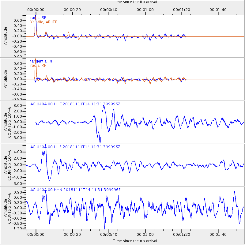
Signal To Noise
| Channel | StoN | STA | LTA |
| AG:U40A:00:HHZ:20181111T14:11:31.399996Z | 7.445929 | 2.1279075E-6 | 2.8578134E-7 |
| AG:U40A:00:HHN:20181111T14:11:31.399996Z | 1.2737942 | 4.1186206E-7 | 3.233349E-7 |
| AG:U40A:00:HHE:20181111T14:11:31.399996Z | 5.900967 | 1.2628067E-6 | 2.1399997E-7 |
| Arrivals |
| Ps | 5.9 SECOND |
| PpPs | 21 SECOND |
| PsPs/PpSs | 27 SECOND |


