You are here: Home > Network List > AV - Alaska Volcano Observatory Stations List
> Station KARR Katmai Rainbow River, Alaska > Earthquake Result Viewer
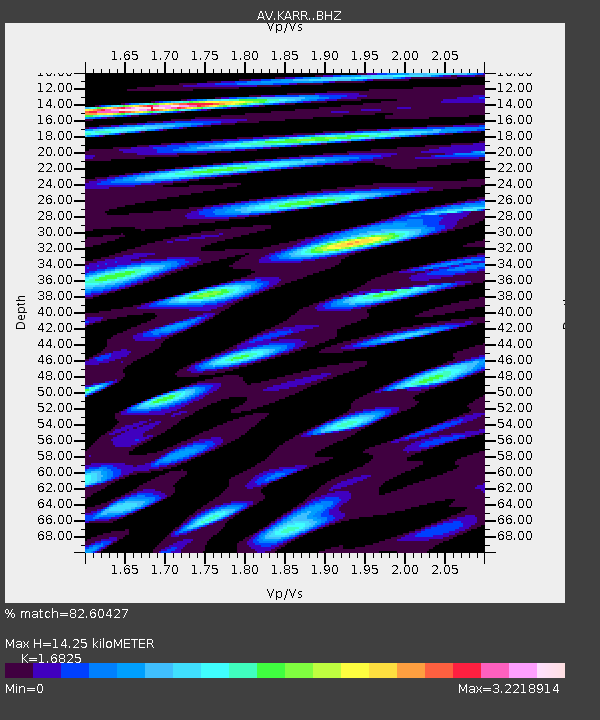
KARR Katmai Rainbow River, Alaska - Earthquake Result Viewer
| Earthquake location: |
Near N Coast Of New Guinea, P.N.G. |
| Earthquake latitude/longitude: |
-4.5/144.9 |
| Earthquake time(UTC): |
2023/06/19 (170) 11:18:11 GMT |
| Earthquake Depth: |
21 km |
| Earthquake Magnitude: |
5.9 Mww |
| Earthquake Catalog/Contributor: |
NEIC PDE/us |
|
| Network: |
AV Alaska Volcano Observatory |
| Station: |
KARR Katmai Rainbow River, Alaska |
| Lat/Lon: |
58.50 N/154.71 W |
| Elevation: |
610 m |
|
| Distance: |
78.9 deg |
| Az: |
27.735 deg |
| Baz: |
242.083 deg |
| Ray Param: |
0.049312312 |
| Estimated Moho Depth: |
14.25 km |
| Estimated Crust Vp/Vs: |
1.68 |
| Assumed Crust Vp: |
6.438 km/s |
| Estimated Crust Vs: |
3.827 km/s |
| Estimated Crust Poisson's Ratio: |
0.23 |
|
| Radial Match: |
82.60427 % |
| Radial Bump: |
400 |
| Transverse Match: |
73.44721 % |
| Transverse Bump: |
400 |
| SOD ConfigId: |
30536071 |
| Insert Time: |
2023-07-03 11:25:02.885 +0000 |
| GWidth: |
2.5 |
| Max Bumps: |
400 |
| Tol: |
0.001 |
|

Signal To Noise
| Channel | StoN | STA | LTA |
| AV:KARR: :BHZ:20230619T11:29:42.299Z | 10.137224 | 1.1645154E-6 | 1.14875185E-7 |
| AV:KARR: :BHN:20230619T11:29:42.299Z | 3.6460543 | 9.783937E-7 | 2.6834317E-7 |
| AV:KARR: :BHE:20230619T11:29:42.299Z | 4.383664 | 1.0369318E-6 | 2.3654454E-7 |
| Arrivals |
| Ps | 1.6 SECOND |
| PpPs | 5.8 SECOND |
| PsPs/PpSs | 7.3 SECOND |


