You are here: Home > Network List > AV - Alaska Volcano Observatory Stations List
> Station MGLS Mageik Landslide, Katmai, Volcanic Group, Alaska > Earthquake Result Viewer
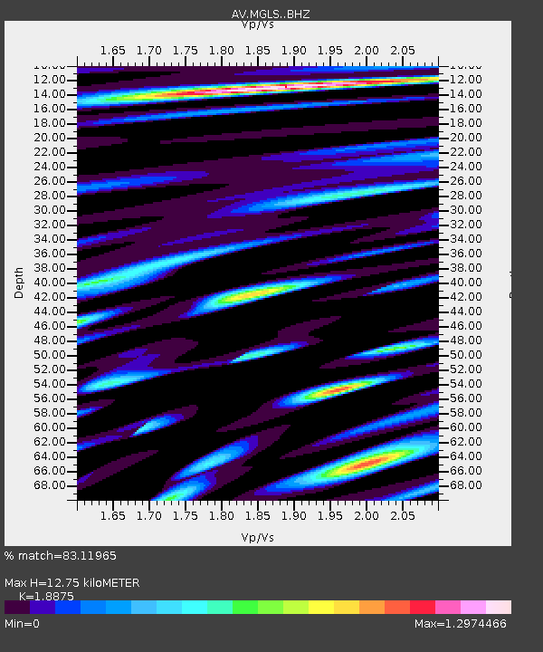
MGLS Mageik Landslide, Katmai, Volcanic Group, Alaska - Earthquake Result Viewer
| Earthquake location: |
Near N Coast Of New Guinea, P.N.G. |
| Earthquake latitude/longitude: |
-4.5/144.9 |
| Earthquake time(UTC): |
2023/06/19 (170) 11:18:11 GMT |
| Earthquake Depth: |
21 km |
| Earthquake Magnitude: |
5.9 Mww |
| Earthquake Catalog/Contributor: |
NEIC PDE/us |
|
| Network: |
AV Alaska Volcano Observatory |
| Station: |
MGLS Mageik Landslide, Katmai, Volcanic Group, Alaska |
| Lat/Lon: |
58.13 N/155.16 W |
| Elevation: |
472 m |
|
| Distance: |
78.5 deg |
| Az: |
27.947 deg |
| Baz: |
241.736 deg |
| Ray Param: |
0.04957213 |
| Estimated Moho Depth: |
12.75 km |
| Estimated Crust Vp/Vs: |
1.89 |
| Assumed Crust Vp: |
6.438 km/s |
| Estimated Crust Vs: |
3.411 km/s |
| Estimated Crust Poisson's Ratio: |
0.30 |
|
| Radial Match: |
83.11965 % |
| Radial Bump: |
400 |
| Transverse Match: |
83.69452 % |
| Transverse Bump: |
400 |
| SOD ConfigId: |
30536071 |
| Insert Time: |
2023-07-03 11:25:25.850 +0000 |
| GWidth: |
2.5 |
| Max Bumps: |
400 |
| Tol: |
0.001 |
|

Signal To Noise
| Channel | StoN | STA | LTA |
| AV:MGLS: :BHZ:20230619T11:29:40.179981Z | 9.470537 | 6.715819E-7 | 7.091276E-8 |
| AV:MGLS: :BHN:20230619T11:29:40.179981Z | 2.8798957 | 3.914811E-7 | 1.3593586E-7 |
| AV:MGLS: :BHE:20230619T11:29:40.179981Z | 2.173663 | 2.3779906E-7 | 1.09400155E-7 |
| Arrivals |
| Ps | 1.8 SECOND |
| PpPs | 5.6 SECOND |
| PsPs/PpSs | 7.4 SECOND |


