You are here: Home > Network List > AV - Alaska Volcano Observatory Stations List
> Station R17L Mt. Peulik Volcano, AVO PLK4, AK, USA > Earthquake Result Viewer
R17L Mt. Peulik Volcano, AVO PLK4, AK, USA - Earthquake Result Viewer
| Earthquake location: |
Near N Coast Of New Guinea, P.N.G. |
| Earthquake latitude/longitude: |
-4.5/144.9 |
| Earthquake time(UTC): |
2023/06/19 (170) 11:18:11 GMT |
| Earthquake Depth: |
21 km |
| Earthquake Magnitude: |
5.9 Mww |
| Earthquake Catalog/Contributor: |
NEIC PDE/us |
|
| Network: |
AV Alaska Volcano Observatory |
| Station: |
R17L Mt. Peulik Volcano, AVO PLK4, AK, USA |
| Lat/Lon: |
57.63 N/156.36 W |
| Elevation: |
524 m |
|
| Distance: |
77.7 deg |
| Az: |
28.084 deg |
| Baz: |
240.753 deg |
| Ray Param: |
0.050128736 |
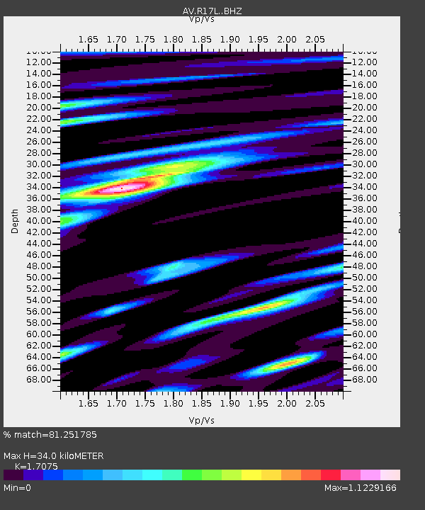
| Estimated Moho Depth: |
34.0 km |
| Estimated Crust Vp/Vs: |
1.71 |
| Assumed Crust Vp: |
6.1 km/s |
| Estimated Crust Vs: |
3.572 km/s |
| Estimated Crust Poisson's Ratio: |
0.24 |
|
| Radial Match: |
81.251785 % |
| Radial Bump: |
400 |
| Transverse Match: |
73.97092 % |
| Transverse Bump: |
400 |
| SOD ConfigId: |
30536071 |
| Insert Time: |
2023-07-03 11:25:51.937 +0000 |
| GWidth: |
2.5 |
| Max Bumps: |
400 |
| Tol: |
0.001 |
|

Signal To Noise
| Channel | StoN | STA | LTA |
| AV:R17L: :BHZ:20230619T11:29:35.749988Z | 4.1809716 | 7.7845664E-7 | 1.8619038E-7 |
| AV:R17L: :BHN:20230619T11:29:35.749988Z | 1.8375164 | 2.2167316E-7 | 1.2063738E-7 |
| AV:R17L: :BHE:20230619T11:29:35.749988Z | 1.2545621 | 2.2772115E-7 | 1.8151444E-7 |
| Arrivals |
| Ps | 4.1 SECOND |
| PpPs | 15 SECOND |
| PsPs/PpSs | 19 SECOND |


