You are here: Home > Network List > CI - Caltech Regional Seismic Network Stations List
> Station SWS Sam W. Stewart, Westmorland, CA, USA > Earthquake Result Viewer
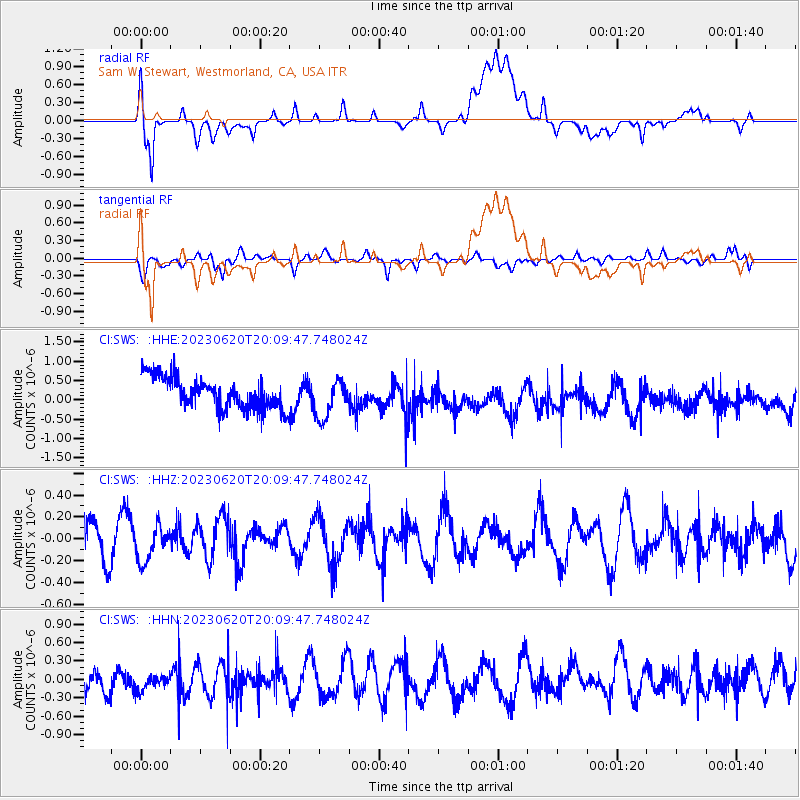
SWS Sam W. Stewart, Westmorland, CA, USA - Earthquake Result Viewer
*The percent match for this event was below the threshold and hence no stack was calculated.
| Earthquake location: |
Fiji Islands Region |
| Earthquake latitude/longitude: |
-17.4/-178.8 |
| Earthquake time(UTC): |
2023/06/20 (171) 19:59:15 GMT |
| Earthquake Depth: |
548 km |
| Earthquake Magnitude: |
5.7 Mww |
| Earthquake Catalog/Contributor: |
NEIC PDE/us |
|
| Network: |
CI Caltech Regional Seismic Network |
| Station: |
SWS Sam W. Stewart, Westmorland, CA, USA |
| Lat/Lon: |
32.94 N/115.80 W |
| Elevation: |
140 m |
|
| Distance: |
78.2 deg |
| Az: |
49.918 deg |
| Baz: |
240.307 deg |
| Ray Param: |
$rayparam |
*The percent match for this event was below the threshold and hence was not used in the summary stack. |
|
| Radial Match: |
51.51988 % |
| Radial Bump: |
400 |
| Transverse Match: |
46.6444 % |
| Transverse Bump: |
400 |
| SOD ConfigId: |
30536071 |
| Insert Time: |
2023-07-04 20:12:51.740 +0000 |
| GWidth: |
2.5 |
| Max Bumps: |
400 |
| Tol: |
0.001 |
|
Signal To Noise
| Channel | StoN | STA | LTA |
| CI:SWS: :HHZ:20230620T20:09:47.748024Z | 0.6642314 | 1.5875193E-7 | 2.3900094E-7 |
| CI:SWS: :HHN:20230620T20:09:47.748024Z | 0.7859397 | 2.3611325E-7 | 3.004216E-7 |
| CI:SWS: :HHE:20230620T20:09:47.748024Z | 1.2244291 | 4.9343527E-7 | 4.029921E-7 |
| Arrivals |
| Ps | |
| PpPs | |
| PsPs/PpSs | |


