You are here: Home > Network List > US - United States National Seismic Network Stations List
> Station EGMT Eagleton, Montana, USA > Earthquake Result Viewer
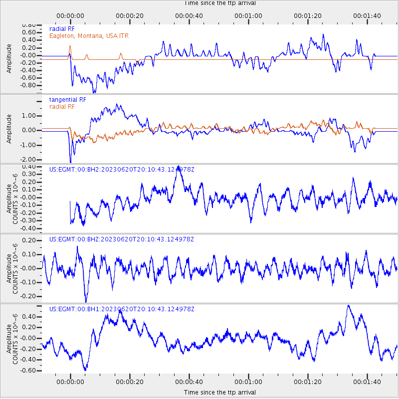
EGMT Eagleton, Montana, USA - Earthquake Result Viewer
*The percent match for this event was below the threshold and hence no stack was calculated.
| Earthquake location: |
Fiji Islands Region |
| Earthquake latitude/longitude: |
-17.4/-178.8 |
| Earthquake time(UTC): |
2023/06/20 (171) 19:59:15 GMT |
| Earthquake Depth: |
548 km |
| Earthquake Magnitude: |
5.7 Mww |
| Earthquake Catalog/Contributor: |
NEIC PDE/us |
|
| Network: |
US United States National Seismic Network |
| Station: |
EGMT Eagleton, Montana, USA |
| Lat/Lon: |
48.02 N/109.75 W |
| Elevation: |
1055 m |
|
| Distance: |
89.5 deg |
| Az: |
38.814 deg |
| Baz: |
243.054 deg |
| Ray Param: |
$rayparam |
*The percent match for this event was below the threshold and hence was not used in the summary stack. |
|
| Radial Match: |
38.058155 % |
| Radial Bump: |
400 |
| Transverse Match: |
38.21488 % |
| Transverse Bump: |
400 |
| SOD ConfigId: |
30536071 |
| Insert Time: |
2023-07-04 20:23:36.905 +0000 |
| GWidth: |
2.5 |
| Max Bumps: |
400 |
| Tol: |
0.001 |
|
Signal To Noise
| Channel | StoN | STA | LTA |
| US:EGMT:00:BHZ:20230620T20:10:43.124978Z | 1.2077098 | 6.95479E-8 | 5.75866E-8 |
| US:EGMT:00:BH1:20230620T20:10:43.124978Z | 2.113468 | 3.7882748E-7 | 1.7924448E-7 |
| US:EGMT:00:BH2:20230620T20:10:43.124978Z | 1.7898906 | 1.9291711E-7 | 1.0778151E-7 |
| Arrivals |
| Ps | |
| PpPs | |
| PsPs/PpSs | |


