You are here: Home > Network List > US - United States National Seismic Network Stations List
> Station MNTX Cornudas Mountains, Texas, USA > Earthquake Result Viewer
MNTX Cornudas Mountains, Texas, USA - Earthquake Result Viewer
*The percent match for this event was below the threshold and hence no stack was calculated.
| Earthquake location: |
Northern Peru |
| Earthquake latitude/longitude: |
-5.1/-77.5 |
| Earthquake time(UTC): |
2010/05/19 (139) 04:15:44 GMT |
| Earthquake Depth: |
140 km |
| Earthquake Magnitude: |
6.0 MB, 6.0 MW, 6.0 MW |
| Earthquake Catalog/Contributor: |
WHDF/NEIC |
|
| Network: |
US United States National Seismic Network |
| Station: |
MNTX Cornudas Mountains, Texas, USA |
| Lat/Lon: |
31.70 N/105.38 W |
| Elevation: |
404 m |
|
| Distance: |
45.2 deg |
| Az: |
325.856 deg |
| Baz: |
139.01 deg |
| Ray Param: |
$rayparam |
*The percent match for this event was below the threshold and hence was not used in the summary stack. |
|
| Radial Match: |
87.02431 % |
| Radial Bump: |
314 |
| Transverse Match: |
90.50729 % |
| Transverse Bump: |
400 |
| SOD ConfigId: |
314592 |
| Insert Time: |
2010-09-04 07:53:54.882 +0000 |
| GWidth: |
2.5 |
| Max Bumps: |
400 |
| Tol: |
0.001 |
|
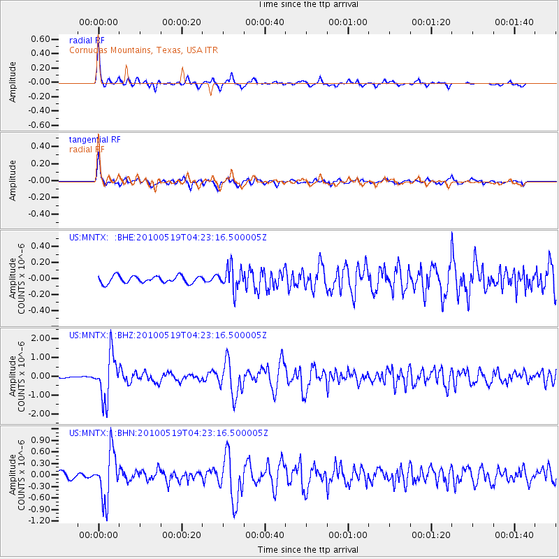
Signal To Noise
| Channel | StoN | STA | LTA |
| US:MNTX: :BHZ:20100519T04:23:16.500005Z | 12.585756 | 1.2040605E-6 | 9.56685E-8 |
| US:MNTX: :BHN:20100519T04:23:16.500005Z | 8.2065735 | 6.419235E-7 | 7.822065E-8 |
| US:MNTX: :BHE:20100519T04:23:16.500005Z | 3.3870327 | 1.4961621E-7 | 4.417324E-8 |
| Arrivals |
| Ps | |
| PpPs | |
| PsPs/PpSs | |


