You are here: Home > Network List > US - United States National Seismic Network Stations List
> Station LAO LASA Array, Montana, USA > Earthquake Result Viewer
LAO LASA Array, Montana, USA - Earthquake Result Viewer
*The percent match for this event was below the threshold and hence no stack was calculated.
| Earthquake location: |
Northern Peru |
| Earthquake latitude/longitude: |
-5.1/-77.5 |
| Earthquake time(UTC): |
2010/05/19 (139) 04:15:44 GMT |
| Earthquake Depth: |
140 km |
| Earthquake Magnitude: |
6.0 MB, 6.0 MW, 6.0 MW |
| Earthquake Catalog/Contributor: |
WHDF/NEIC |
|
| Network: |
US United States National Seismic Network |
| Station: |
LAO LASA Array, Montana, USA |
| Lat/Lon: |
46.69 N/106.22 W |
| Elevation: |
902 m |
|
| Distance: |
57.5 deg |
| Az: |
336.923 deg |
| Baz: |
145.445 deg |
| Ray Param: |
$rayparam |
*The percent match for this event was below the threshold and hence was not used in the summary stack. |
|
| Radial Match: |
69.73058 % |
| Radial Bump: |
400 |
| Transverse Match: |
64.91811 % |
| Transverse Bump: |
400 |
| SOD ConfigId: |
314592 |
| Insert Time: |
2010-09-04 07:54:06.403 +0000 |
| GWidth: |
2.5 |
| Max Bumps: |
400 |
| Tol: |
0.001 |
|
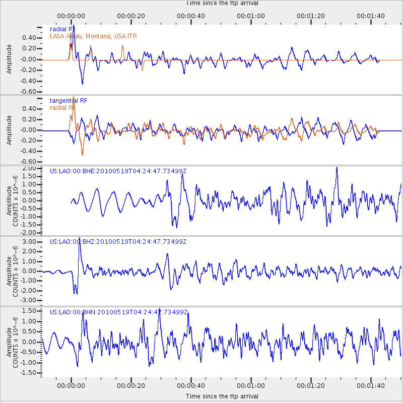
Signal To Noise
| Channel | StoN | STA | LTA |
| US:LAO:00:BHZ:20100519T04:24:47.73499Z | 11.490898 | 1.4251398E-6 | 1.2402336E-7 |
| US:LAO:00:BHN:20100519T04:24:47.73499Z | 1.6913217 | 6.206978E-7 | 3.6698978E-7 |
| US:LAO:00:BHE:20100519T04:24:47.73499Z | 1.7666178 | 7.0556854E-7 | 3.9938948E-7 |
| Arrivals |
| Ps | |
| PpPs | |
| PsPs/PpSs | |


