You are here: Home > Network List > US - United States National Seismic Network Stations List
> Station DGMT Dagmar, Montana, USA > Earthquake Result Viewer
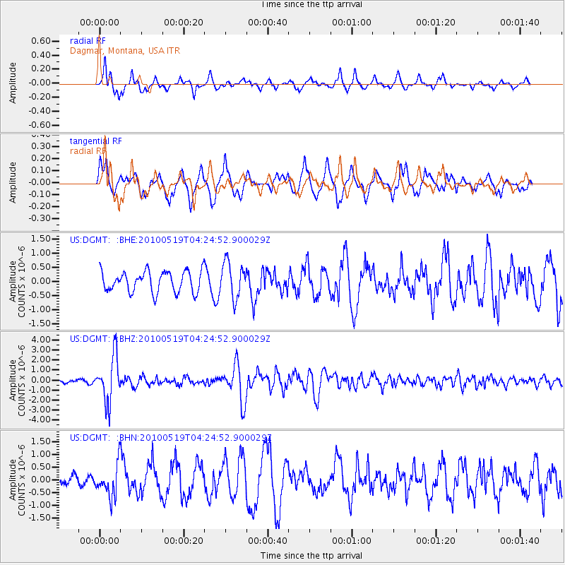
DGMT Dagmar, Montana, USA - Earthquake Result Viewer
*The percent match for this event was below the threshold and hence no stack was calculated.
| Earthquake location: |
Northern Peru |
| Earthquake latitude/longitude: |
-5.1/-77.5 |
| Earthquake time(UTC): |
2010/05/19 (139) 04:15:44 GMT |
| Earthquake Depth: |
140 km |
| Earthquake Magnitude: |
6.0 MB, 6.0 MW, 6.0 MW |
| Earthquake Catalog/Contributor: |
WHDF/NEIC |
|
| Network: |
US United States National Seismic Network |
| Station: |
DGMT Dagmar, Montana, USA |
| Lat/Lon: |
48.47 N/104.20 W |
| Elevation: |
0.0 m |
|
| Distance: |
58.2 deg |
| Az: |
339.432 deg |
| Baz: |
148.274 deg |
| Ray Param: |
$rayparam |
*The percent match for this event was below the threshold and hence was not used in the summary stack. |
|
| Radial Match: |
78.66641 % |
| Radial Bump: |
400 |
| Transverse Match: |
66.08325 % |
| Transverse Bump: |
400 |
| SOD ConfigId: |
314592 |
| Insert Time: |
2010-09-04 07:54:06.738 +0000 |
| GWidth: |
2.5 |
| Max Bumps: |
400 |
| Tol: |
0.001 |
|
Signal To Noise
| Channel | StoN | STA | LTA |
| US:DGMT: :BHZ:20100519T04:24:52.900029Z | 18.814222 | 2.35611E-6 | 1.2523026E-7 |
| US:DGMT: :BHN:20100519T04:24:52.900029Z | 1.1138761 | 6.5218825E-7 | 5.8551234E-7 |
| US:DGMT: :BHE:20100519T04:24:52.900029Z | 1.7135684 | 6.332496E-7 | 3.6955026E-7 |
| Arrivals |
| Ps | |
| PpPs | |
| PsPs/PpSs | |


