You are here: Home > Network List > US - United States National Seismic Network Stations List
> Station AMTX Amarillo, Texas, USA > Earthquake Result Viewer
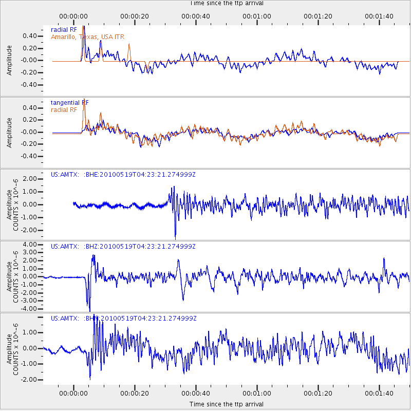
AMTX Amarillo, Texas, USA - Earthquake Result Viewer
*The percent match for this event was below the threshold and hence no stack was calculated.
| Earthquake location: |
Northern Peru |
| Earthquake latitude/longitude: |
-5.1/-77.5 |
| Earthquake time(UTC): |
2010/05/19 (139) 04:15:44 GMT |
| Earthquake Depth: |
140 km |
| Earthquake Magnitude: |
6.0 MB, 6.0 MW, 6.0 MW |
| Earthquake Catalog/Contributor: |
WHDF/NEIC |
|
| Network: |
US United States National Seismic Network |
| Station: |
AMTX Amarillo, Texas, USA |
| Lat/Lon: |
34.53 N/101.41 W |
| Elevation: |
1010 m |
|
| Distance: |
45.4 deg |
| Az: |
332.0 deg |
| Baz: |
145.498 deg |
| Ray Param: |
$rayparam |
*The percent match for this event was below the threshold and hence was not used in the summary stack. |
|
| Radial Match: |
53.78272 % |
| Radial Bump: |
400 |
| Transverse Match: |
39.04152 % |
| Transverse Bump: |
400 |
| SOD ConfigId: |
314592 |
| Insert Time: |
2010-09-04 07:54:18.709 +0000 |
| GWidth: |
2.5 |
| Max Bumps: |
400 |
| Tol: |
0.001 |
|
Signal To Noise
| Channel | StoN | STA | LTA |
| US:AMTX: :BHZ:20100519T04:23:21.274999Z | 5.876943 | 8.324352E-7 | 1.4164425E-7 |
| US:AMTX: :BHN:20100519T04:23:21.274999Z | 1.2786453 | 2.7857942E-7 | 2.1787075E-7 |
| US:AMTX: :BHE:20100519T04:23:21.274999Z | 2.3471045 | 2.4933684E-7 | 1.0623167E-7 |
| Arrivals |
| Ps | |
| PpPs | |
| PsPs/PpSs | |


