You are here: Home > Network List > NM - Cooperative New Madrid Seismic Network Stations List
> Station LPAR Lepanto,AR > Earthquake Result Viewer
LPAR Lepanto,AR - Earthquake Result Viewer
| Earthquake location: |
North Atlantic Ocean |
| Earthquake latitude/longitude: |
15.6/-49.9 |
| Earthquake time(UTC): |
2018/11/11 (315) 14:03:59 GMT |
| Earthquake Depth: |
10 km |
| Earthquake Magnitude: |
6.2 mb |
| Earthquake Catalog/Contributor: |
NEIC PDE/us |
|
| Network: |
NM Cooperative New Madrid Seismic Network |
| Station: |
LPAR Lepanto,AR |
| Lat/Lon: |
35.60 N/90.30 W |
| Elevation: |
67 m |
|
| Distance: |
41.2 deg |
| Az: |
306.648 deg |
| Baz: |
108.396 deg |
| Ray Param: |
0.073936865 |
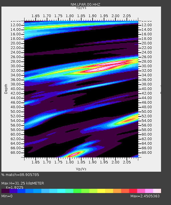
| Estimated Moho Depth: |
31.25 km |
| Estimated Crust Vp/Vs: |
1.92 |
| Assumed Crust Vp: |
6.273 km/s |
| Estimated Crust Vs: |
3.263 km/s |
| Estimated Crust Poisson's Ratio: |
0.31 |
|
| Radial Match: |
89.905785 % |
| Radial Bump: |
274 |
| Transverse Match: |
59.04042 % |
| Transverse Bump: |
369 |
| SOD ConfigId: |
3131071 |
| Insert Time: |
2018-11-25 14:22:07.089 +0000 |
| GWidth: |
2.5 |
| Max Bumps: |
400 |
| Tol: |
0.001 |
|

Signal To Noise
| Channel | StoN | STA | LTA |
| NM:LPAR:00:HHZ:20181111T14:11:13.480013Z | 5.612365 | 2.2136287E-6 | 3.9441994E-7 |
| NM:LPAR:00:HHN:20181111T14:11:13.480013Z | 0.8718601 | 1.0040354E-6 | 1.1516015E-6 |
| NM:LPAR:00:HHE:20181111T14:11:13.480013Z | 1.0369848 | 1.3525643E-6 | 1.3043241E-6 |
| Arrivals |
| Ps | 4.9 SECOND |
| PpPs | 14 SECOND |
| PsPs/PpSs | 19 SECOND |


