You are here: Home > Network List > TA - USArray Transportable Network (new EarthScope stations) Stations List
> Station K22A Casper, WY, USA > Earthquake Result Viewer
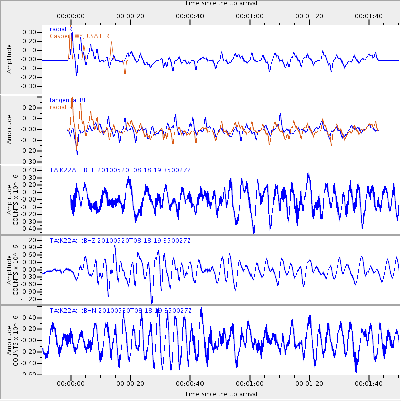
K22A Casper, WY, USA - Earthquake Result Viewer
*The percent match for this event was below the threshold and hence no stack was calculated.
| Earthquake location: |
Southeast Of Easter Island |
| Earthquake latitude/longitude: |
-39.1/-92.2 |
| Earthquake time(UTC): |
2010/05/20 (140) 08:06:28 GMT |
| Earthquake Depth: |
10 km |
| Earthquake Magnitude: |
5.5 MB, 5.6 MS, 5.9 MW, 5.9 MW |
| Earthquake Catalog/Contributor: |
WHDF/NEIC |
|
| Network: |
TA USArray Transportable Network (new EarthScope stations) |
| Station: |
K22A Casper, WY, USA |
| Lat/Lon: |
42.65 N/106.52 W |
| Elevation: |
1686 m |
|
| Distance: |
82.4 deg |
| Az: |
349.358 deg |
| Baz: |
168.763 deg |
| Ray Param: |
$rayparam |
*The percent match for this event was below the threshold and hence was not used in the summary stack. |
|
| Radial Match: |
79.21311 % |
| Radial Bump: |
382 |
| Transverse Match: |
61.33957 % |
| Transverse Bump: |
400 |
| SOD ConfigId: |
314592 |
| Insert Time: |
2010-09-04 08:05:28.513 +0000 |
| GWidth: |
2.5 |
| Max Bumps: |
400 |
| Tol: |
0.001 |
|
Signal To Noise
| Channel | StoN | STA | LTA |
| TA:K22A: :BHZ:20100520T08:18:19.350027Z | 2.703487 | 2.2309494E-7 | 8.252118E-8 |
| TA:K22A: :BHN:20100520T08:18:19.350027Z | 0.71536607 | 1.0376738E-7 | 1.4505493E-7 |
| TA:K22A: :BHE:20100520T08:18:19.350027Z | 0.7297099 | 8.915755E-8 | 1.2218219E-7 |
| Arrivals |
| Ps | |
| PpPs | |
| PsPs/PpSs | |


