You are here: Home > Network List > TX - Texas Seismological Network Stations List
> Station WTFS Witchita Falls > Earthquake Result Viewer
WTFS Witchita Falls - Earthquake Result Viewer
*The percent match for this event was below the threshold and hence no stack was calculated.
| Earthquake location: |
Southern Mid-Atlantic Ridge |
| Earthquake latitude/longitude: |
-12.9/-14.7 |
| Earthquake time(UTC): |
2023/06/21 (172) 04:10:53 GMT |
| Earthquake Depth: |
10 km |
| Earthquake Magnitude: |
5.5 mww |
| Earthquake Catalog/Contributor: |
NEIC PDE/us |
|
| Network: |
TX Texas Seismological Network |
| Station: |
WTFS Witchita Falls |
| Lat/Lon: |
33.77 N/98.46 W |
| Elevation: |
277 m |
|
| Distance: |
92.0 deg |
| Az: |
304.038 deg |
| Baz: |
104.045 deg |
| Ray Param: |
$rayparam |
*The percent match for this event was below the threshold and hence was not used in the summary stack. |
|
| Radial Match: |
66.70502 % |
| Radial Bump: |
400 |
| Transverse Match: |
56.4612 % |
| Transverse Bump: |
351 |
| SOD ConfigId: |
30536071 |
| Insert Time: |
2023-07-05 04:30:05.230 +0000 |
| GWidth: |
2.5 |
| Max Bumps: |
400 |
| Tol: |
0.001 |
|
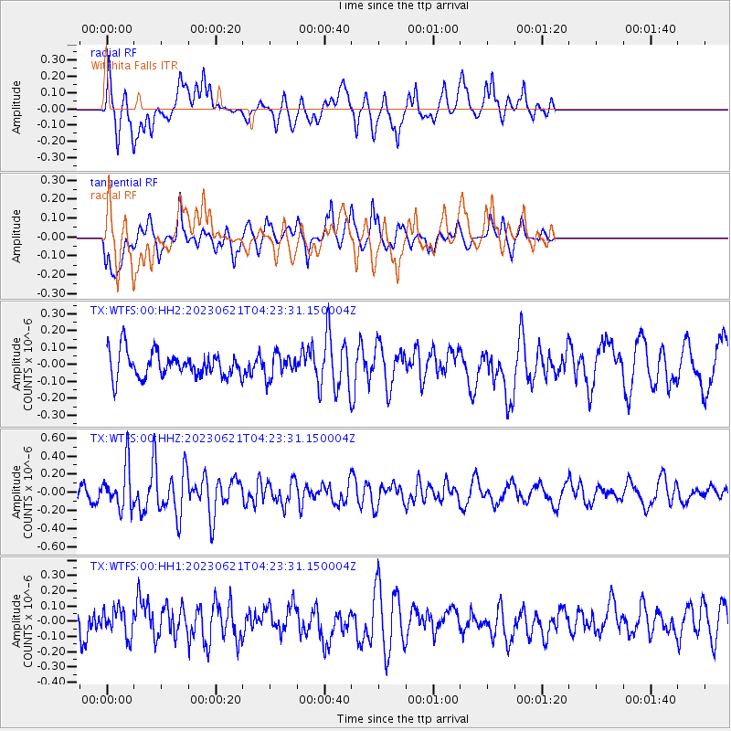
Signal To Noise
| Channel | StoN | STA | LTA |
| TX:WTFS:00:HHZ:20230621T04:23:31.150004Z | 3.889729 | 2.4165095E-7 | 6.2125395E-8 |
| TX:WTFS:00:HH1:20230621T04:23:31.150004Z | 1.088992 | 8.993154E-8 | 8.2582375E-8 |
| TX:WTFS:00:HH2:20230621T04:23:31.150004Z | 0.9088939 | 6.8489435E-8 | 7.5354706E-8 |
| Arrivals |
| Ps | |
| PpPs | |
| PsPs/PpSs | |


