You are here: Home > Network List > NM - Cooperative New Madrid Seismic Network Stations List
> Station UTMT Martin, TN > Earthquake Result Viewer
UTMT Martin, TN - Earthquake Result Viewer
| Earthquake location: |
North Atlantic Ocean |
| Earthquake latitude/longitude: |
15.6/-49.9 |
| Earthquake time(UTC): |
2018/11/11 (315) 14:03:59 GMT |
| Earthquake Depth: |
10 km |
| Earthquake Magnitude: |
6.2 mb |
| Earthquake Catalog/Contributor: |
NEIC PDE/us |
|
| Network: |
NM Cooperative New Madrid Seismic Network |
| Station: |
UTMT Martin, TN |
| Lat/Lon: |
36.35 N/88.86 W |
| Elevation: |
110 m |
|
| Distance: |
40.4 deg |
| Az: |
308.319 deg |
| Baz: |
110.501 deg |
| Ray Param: |
0.07444591 |
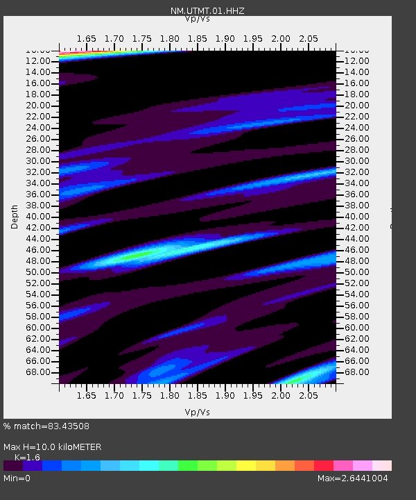
| Estimated Moho Depth: |
10.0 km |
| Estimated Crust Vp/Vs: |
1.60 |
| Assumed Crust Vp: |
6.444 km/s |
| Estimated Crust Vs: |
4.027 km/s |
| Estimated Crust Poisson's Ratio: |
0.18 |
|
| Radial Match: |
83.43508 % |
| Radial Bump: |
400 |
| Transverse Match: |
54.0784 % |
| Transverse Bump: |
400 |
| SOD ConfigId: |
3131071 |
| Insert Time: |
2018-11-25 14:22:17.427 +0000 |
| GWidth: |
2.5 |
| Max Bumps: |
400 |
| Tol: |
0.001 |
|
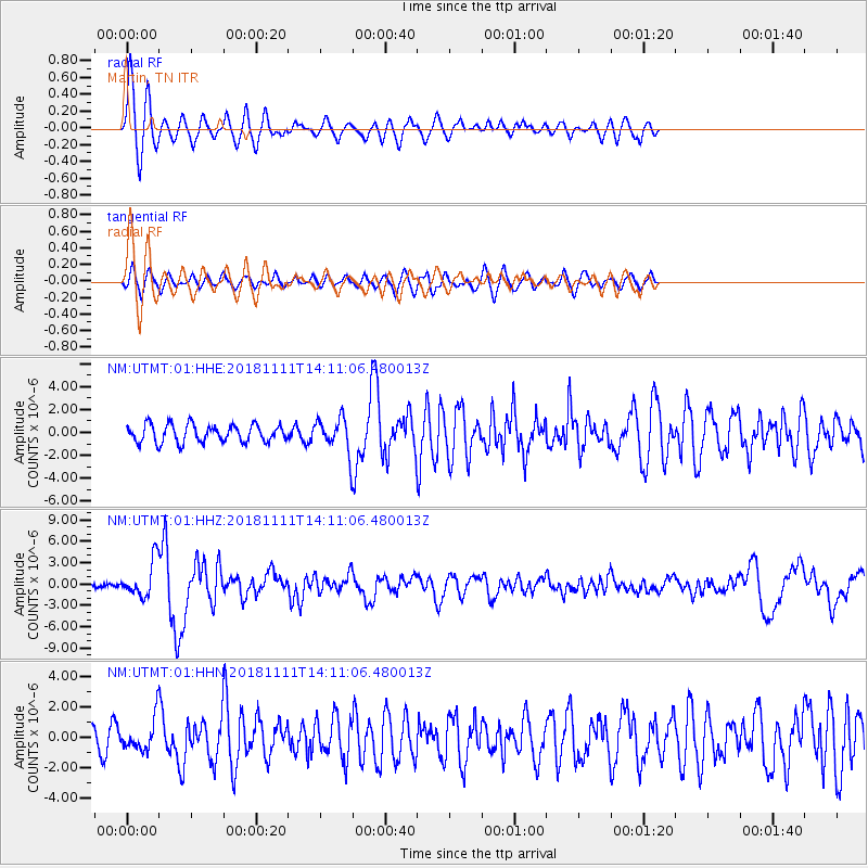
Signal To Noise
| Channel | StoN | STA | LTA |
| NM:UTMT:01:HHZ:20181111T14:11:06.480013Z | 5.2712264 | 2.4695798E-6 | 4.6850195E-7 |
| NM:UTMT:01:HHN:20181111T14:11:06.480013Z | 0.8946243 | 9.905959E-7 | 1.1072758E-6 |
| NM:UTMT:01:HHE:20181111T14:11:06.480013Z | 1.8537734 | 1.428848E-6 | 7.707782E-7 |
| Arrivals |
| Ps | 1.0 SECOND |
| PpPs | 3.7 SECOND |
| PsPs/PpSs | 4.7 SECOND |


