You are here: Home > Network List > TA - USArray Transportable Network (new EarthScope stations) Stations List
> Station 137A Heron Place, Grans Saline, TX, USA > Earthquake Result Viewer
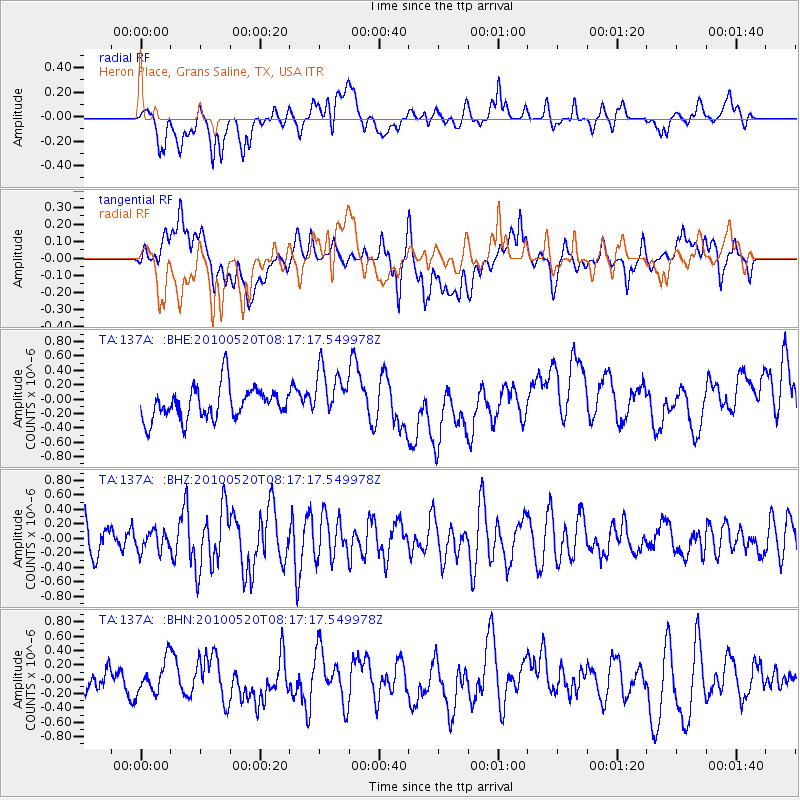
137A Heron Place, Grans Saline, TX, USA - Earthquake Result Viewer
*The percent match for this event was below the threshold and hence no stack was calculated.
| Earthquake location: |
Southeast Of Easter Island |
| Earthquake latitude/longitude: |
-39.1/-92.2 |
| Earthquake time(UTC): |
2010/05/20 (140) 08:06:28 GMT |
| Earthquake Depth: |
10 km |
| Earthquake Magnitude: |
5.5 MB, 5.6 MS, 5.9 MW, 5.9 MW |
| Earthquake Catalog/Contributor: |
WHDF/NEIC |
|
| Network: |
TA USArray Transportable Network (new EarthScope stations) |
| Station: |
137A Heron Place, Grans Saline, TX, USA |
| Lat/Lon: |
32.60 N/95.76 W |
| Elevation: |
141 m |
|
| Distance: |
71.4 deg |
| Az: |
356.796 deg |
| Baz: |
177.046 deg |
| Ray Param: |
$rayparam |
*The percent match for this event was below the threshold and hence was not used in the summary stack. |
|
| Radial Match: |
57.22559 % |
| Radial Bump: |
400 |
| Transverse Match: |
34.858517 % |
| Transverse Bump: |
400 |
| SOD ConfigId: |
314592 |
| Insert Time: |
2010-09-04 08:08:31.316 +0000 |
| GWidth: |
2.5 |
| Max Bumps: |
400 |
| Tol: |
0.001 |
|
Signal To Noise
| Channel | StoN | STA | LTA |
| TA:137A: :BHZ:20100520T08:17:17.549978Z | 0.9548894 | 1.4022264E-7 | 1.4684699E-7 |
| TA:137A: :BHN:20100520T08:17:17.549978Z | 1.0187227 | 2.2885642E-7 | 2.2465038E-7 |
| TA:137A: :BHE:20100520T08:17:17.549978Z | 1.5805284 | 3.5638942E-7 | 2.2548753E-7 |
| Arrivals |
| Ps | |
| PpPs | |
| PsPs/PpSs | |


