You are here: Home > Network List > TX - Texas Seismological Network Stations List
> Station FW11 UT at Arlington > Earthquake Result Viewer
FW11 UT at Arlington - Earthquake Result Viewer
| Earthquake location: |
North Atlantic Ocean |
| Earthquake latitude/longitude: |
15.6/-49.9 |
| Earthquake time(UTC): |
2018/11/11 (315) 14:03:59 GMT |
| Earthquake Depth: |
10 km |
| Earthquake Magnitude: |
6.2 mb |
| Earthquake Catalog/Contributor: |
NEIC PDE/us |
|
| Network: |
TX Texas Seismological Network |
| Station: |
FW11 UT at Arlington |
| Lat/Lon: |
32.72 N/97.13 W |
| Elevation: |
198 m |
|
| Distance: |
46.0 deg |
| Az: |
300.592 deg |
| Baz: |
100.183 deg |
| Ray Param: |
0.07092093 |
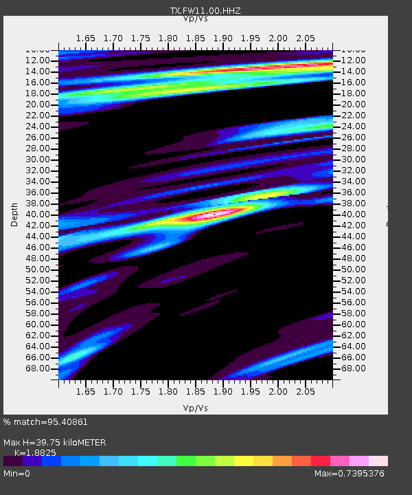
| Estimated Moho Depth: |
39.75 km |
| Estimated Crust Vp/Vs: |
1.88 |
| Assumed Crust Vp: |
6.38 km/s |
| Estimated Crust Vs: |
3.389 km/s |
| Estimated Crust Poisson's Ratio: |
0.30 |
|
| Radial Match: |
95.40861 % |
| Radial Bump: |
332 |
| Transverse Match: |
78.67523 % |
| Transverse Bump: |
400 |
| SOD ConfigId: |
3131071 |
| Insert Time: |
2018-11-25 14:23:03.180 +0000 |
| GWidth: |
2.5 |
| Max Bumps: |
400 |
| Tol: |
0.001 |
|
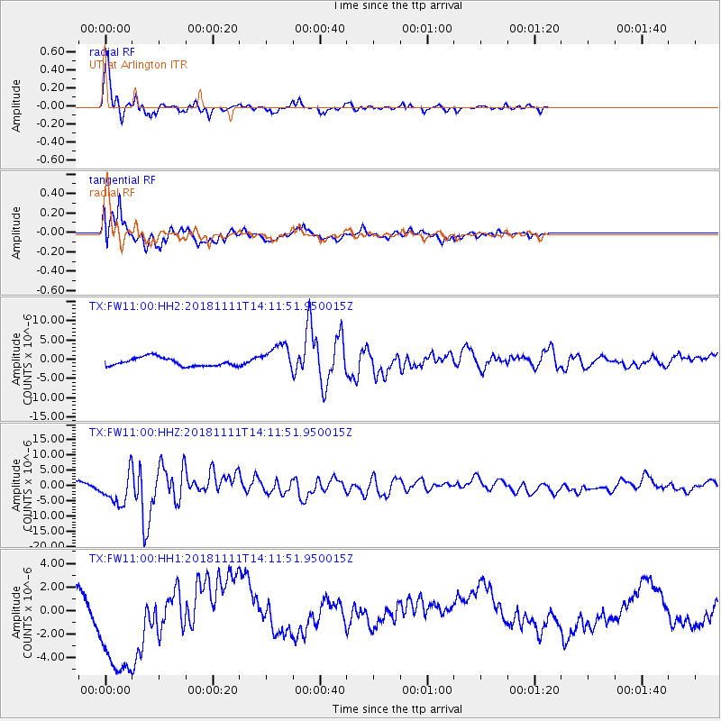
Signal To Noise
| Channel | StoN | STA | LTA |
| TX:FW11:00:HHZ:20181111T14:11:51.950015Z | 3.6245654 | 5.5534356E-6 | 1.5321659E-6 |
| TX:FW11:00:HH1:20181111T14:11:51.950015Z | 2.7547777 | 5.2009773E-6 | 1.8879845E-6 |
| TX:FW11:00:HH2:20181111T14:11:51.950015Z | 3.1466837 | 3.4587974E-6 | 1.0991882E-6 |
| Arrivals |
| Ps | 5.8 SECOND |
| PpPs | 17 SECOND |
| PsPs/PpSs | 23 SECOND |


