You are here: Home > Network List > TX - Texas Seismological Network Stations List
> Station FW15 Z > Earthquake Result Viewer
FW15 Z - Earthquake Result Viewer
| Earthquake location: |
North Atlantic Ocean |
| Earthquake latitude/longitude: |
15.6/-49.9 |
| Earthquake time(UTC): |
2018/11/11 (315) 14:03:59 GMT |
| Earthquake Depth: |
10 km |
| Earthquake Magnitude: |
6.2 mb |
| Earthquake Catalog/Contributor: |
NEIC PDE/us |
|
| Network: |
TX Texas Seismological Network |
| Station: |
FW15 Z |
| Lat/Lon: |
32.70 N/97.37 W |
| Elevation: |
192 m |
|
| Distance: |
46.2 deg |
| Az: |
300.517 deg |
| Baz: |
100.002 deg |
| Ray Param: |
0.070798635 |
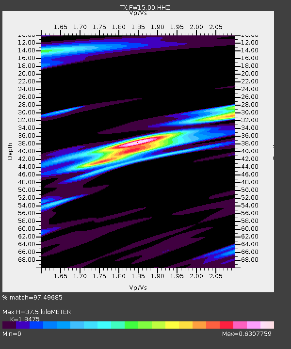
| Estimated Moho Depth: |
37.5 km |
| Estimated Crust Vp/Vs: |
1.85 |
| Assumed Crust Vp: |
6.38 km/s |
| Estimated Crust Vs: |
3.454 km/s |
| Estimated Crust Poisson's Ratio: |
0.29 |
|
| Radial Match: |
97.49685 % |
| Radial Bump: |
233 |
| Transverse Match: |
86.96672 % |
| Transverse Bump: |
400 |
| SOD ConfigId: |
3131071 |
| Insert Time: |
2018-11-25 14:23:09.581 +0000 |
| GWidth: |
2.5 |
| Max Bumps: |
400 |
| Tol: |
0.001 |
|
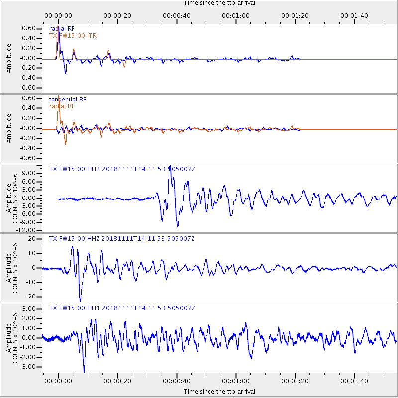
Signal To Noise
| Channel | StoN | STA | LTA |
| TX:FW15:00:HHZ:20181111T14:11:53.505007Z | 20.488766 | 4.4860158E-6 | 2.1895002E-7 |
| TX:FW15:00:HH1:20181111T14:11:53.505007Z | 0.86965555 | 1.9746193E-7 | 2.2705763E-7 |
| TX:FW15:00:HH2:20181111T14:11:53.505007Z | 7.00432 | 1.5004928E-6 | 2.142239E-7 |
| Arrivals |
| Ps | 5.3 SECOND |
| PpPs | 16 SECOND |
| PsPs/PpSs | 21 SECOND |


