You are here: Home > Network List > AV - Alaska Volcano Observatory Stations List
> Station SPCN Ckakachatna North Broadband, Mount Spurr, Alaska > Earthquake Result Viewer
SPCN Ckakachatna North Broadband, Mount Spurr, Alaska - Earthquake Result Viewer
| Earthquake location: |
Hokkaido, Japan Region |
| Earthquake latitude/longitude: |
45.8/143.1 |
| Earthquake time(UTC): |
2023/06/23 (174) 17:39:13 GMT |
| Earthquake Depth: |
318 km |
| Earthquake Magnitude: |
5.6 Mww |
| Earthquake Catalog/Contributor: |
NEIC PDE/us |
|
| Network: |
AV Alaska Volcano Observatory |
| Station: |
SPCN Ckakachatna North Broadband, Mount Spurr, Alaska |
| Lat/Lon: |
61.22 N/152.19 W |
| Elevation: |
735 m |
|
| Distance: |
39.6 deg |
| Az: |
43.293 deg |
| Baz: |
277.577 deg |
| Ray Param: |
0.07353265 |
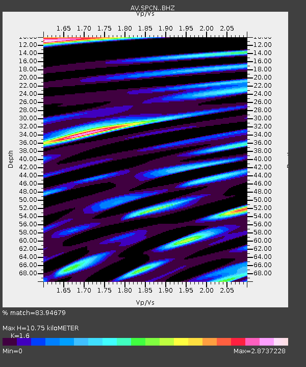
| Estimated Moho Depth: |
10.75 km |
| Estimated Crust Vp/Vs: |
1.60 |
| Assumed Crust Vp: |
6.566 km/s |
| Estimated Crust Vs: |
4.104 km/s |
| Estimated Crust Poisson's Ratio: |
0.18 |
|
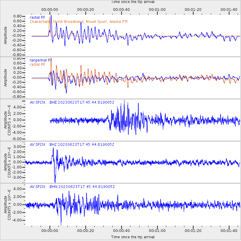
| Radial Match: |
83.94679 % |
| Radial Bump: |
400 |
| Transverse Match: |
88.64278 % |
| Transverse Bump: |
400 |
| SOD ConfigId: |
30536071 |
| Insert Time: |
2023-07-07 17:48:29.734 +0000 |
| GWidth: |
2.5 |
| Max Bumps: |
400 |
| Tol: |
0.001 |
|
Signal To Noise
| Channel | StoN | STA | LTA |
| AV:SPCN: :BHZ:20230623T17:45:44.819005Z | 11.074978 | 1.512367E-6 | 1.365571E-7 |
| AV:SPCN: :BHN:20230623T17:45:44.819005Z | 2.5136092 | 8.1201034E-7 | 3.2304558E-7 |
| AV:SPCN: :BHE:20230623T17:45:44.819005Z | 2.5223532 | 1.1279903E-6 | 4.4719764E-7 |
| Arrivals |
| Ps | 1.1 SECOND |
| PpPs | 3.9 SECOND |
| PsPs/PpSs | 5.0 SECOND |


