You are here: Home > Network List > TX - Texas Seismological Network Stations List
> Station PB06 Permian Basin 6 > Earthquake Result Viewer
PB06 Permian Basin 6 - Earthquake Result Viewer

| Earthquake location: |
North Atlantic Ocean |
| Earthquake latitude/longitude: |
15.6/-49.9 |
| Earthquake time(UTC): |
2018/11/11 (315) 14:03:59 GMT |
| Earthquake Depth: |
10 km |
| Earthquake Magnitude: |
6.2 mb |
| Earthquake Catalog/Contributor: |
NEIC PDE/us |
|
| Network: |
TX Texas Seismological Network |
| Station: |
PB06 Permian Basin 6 |
| Lat/Lon: |
31.65 N/103.22 W |
| Elevation: |
831 m |
|
| Distance: |
51.0 deg |
| Az: |
298.24 deg |
| Baz: |
95.392 deg |
| Ray Param: |
0.06771069 |
| Estimated Moho Depth: |
15.75 km |
| Estimated Crust Vp/Vs: |
2.07 |
| Assumed Crust Vp: |
6.121 km/s |
| Estimated Crust Vs: |
2.957 km/s |
| Estimated Crust Poisson's Ratio: |
0.35 |
|
| Radial Match: |
87.80579 % |
| Radial Bump: |
400 |
| Transverse Match: |
69.17298 % |
| Transverse Bump: |
400 |
| SOD ConfigId: |
3131071 |
| Insert Time: |
2018-11-25 14:23:29.937 +0000 |
| GWidth: |
2.5 |
| Max Bumps: |
400 |
| Tol: |
0.001 |
|
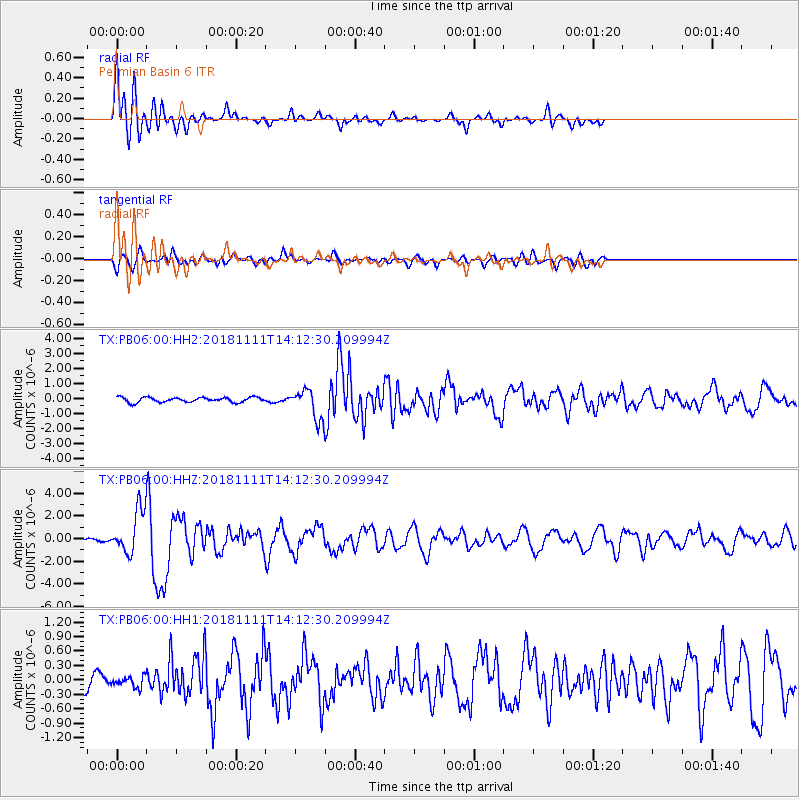
Signal To Noise
| Channel | StoN | STA | LTA |
| TX:PB06:00:HHZ:20181111T14:12:30.209994Z | 7.230672 | 1.8744363E-6 | 2.5923404E-7 |
| TX:PB06:00:HH1:20181111T14:12:30.209994Z | 0.59113747 | 1.0759388E-7 | 1.820116E-7 |
| TX:PB06:00:HH2:20181111T14:12:30.209994Z | 5.9568233 | 9.739605E-7 | 1.6350334E-7 |
| Arrivals |
| Ps | 2.9 SECOND |
| PpPs | 7.6 SECOND |
| PsPs/PpSs | 10 SECOND |


