You are here: Home > Network List > TX - Texas Seismological Network Stations List
> Station SN01 Snyder 1 > Earthquake Result Viewer
SN01 Snyder 1 - Earthquake Result Viewer
| Earthquake location: |
North Atlantic Ocean |
| Earthquake latitude/longitude: |
15.6/-49.9 |
| Earthquake time(UTC): |
2018/11/11 (315) 14:03:59 GMT |
| Earthquake Depth: |
10 km |
| Earthquake Magnitude: |
6.2 mb |
| Earthquake Catalog/Contributor: |
NEIC PDE/us |
|
| Network: |
TX Texas Seismological Network |
| Station: |
SN01 Snyder 1 |
| Lat/Lon: |
32.86 N/100.89 W |
| Elevation: |
717 m |
|
| Distance: |
49.1 deg |
| Az: |
300.105 deg |
| Baz: |
97.827 deg |
| Ray Param: |
0.06889094 |
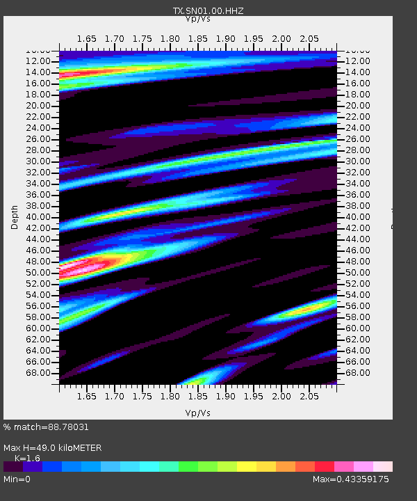
| Estimated Moho Depth: |
49.0 km |
| Estimated Crust Vp/Vs: |
1.60 |
| Assumed Crust Vp: |
6.426 km/s |
| Estimated Crust Vs: |
4.016 km/s |
| Estimated Crust Poisson's Ratio: |
0.18 |
|
| Radial Match: |
88.78031 % |
| Radial Bump: |
384 |
| Transverse Match: |
83.39985 % |
| Transverse Bump: |
316 |
| SOD ConfigId: |
3131071 |
| Insert Time: |
2018-11-25 14:23:47.882 +0000 |
| GWidth: |
2.5 |
| Max Bumps: |
400 |
| Tol: |
0.001 |
|
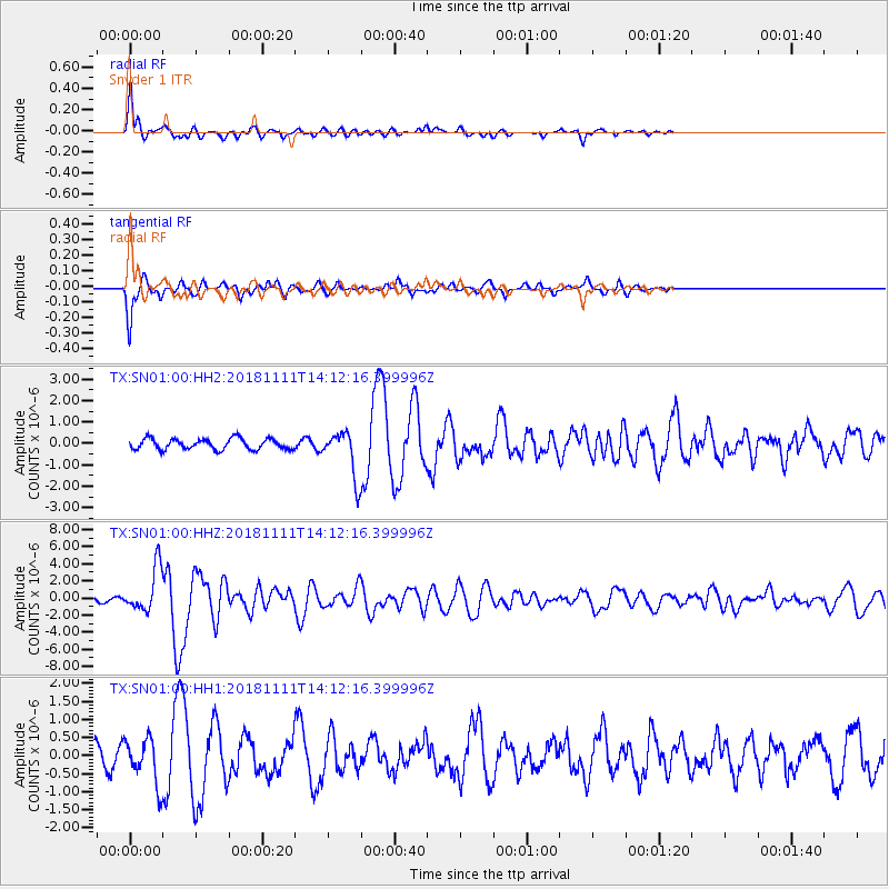
Signal To Noise
| Channel | StoN | STA | LTA |
| TX:SN01:00:HHZ:20181111T14:12:16.399996Z | 11.886274 | 2.5631848E-6 | 2.1564242E-7 |
| TX:SN01:00:HH1:20181111T14:12:16.399996Z | 3.0025537 | 6.184577E-7 | 2.0597724E-7 |
| TX:SN01:00:HH2:20181111T14:12:16.399996Z | 4.243029 | 1.0587713E-6 | 2.4953195E-7 |
| Arrivals |
| Ps | 4.9 SECOND |
| PpPs | 19 SECOND |
| PsPs/PpSs | 23 SECOND |


