You are here: Home > Network List > TX - Texas Seismological Network Stations List
> Station SN04 Snyder 4 > Earthquake Result Viewer
SN04 Snyder 4 - Earthquake Result Viewer
| Earthquake location: |
North Atlantic Ocean |
| Earthquake latitude/longitude: |
15.6/-49.9 |
| Earthquake time(UTC): |
2018/11/11 (315) 14:03:59 GMT |
| Earthquake Depth: |
10 km |
| Earthquake Magnitude: |
6.2 mb |
| Earthquake Catalog/Contributor: |
NEIC PDE/us |
|
| Network: |
TX Texas Seismological Network |
| Station: |
SN04 Snyder 4 |
| Lat/Lon: |
32.90 N/100.87 W |
| Elevation: |
716 m |
|
| Distance: |
49.1 deg |
| Az: |
300.157 deg |
| Baz: |
97.871 deg |
| Ray Param: |
0.06889888 |
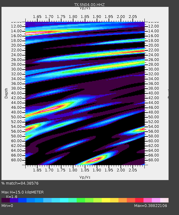
| Estimated Moho Depth: |
15.0 km |
| Estimated Crust Vp/Vs: |
1.60 |
| Assumed Crust Vp: |
6.426 km/s |
| Estimated Crust Vs: |
4.016 km/s |
| Estimated Crust Poisson's Ratio: |
0.18 |
|
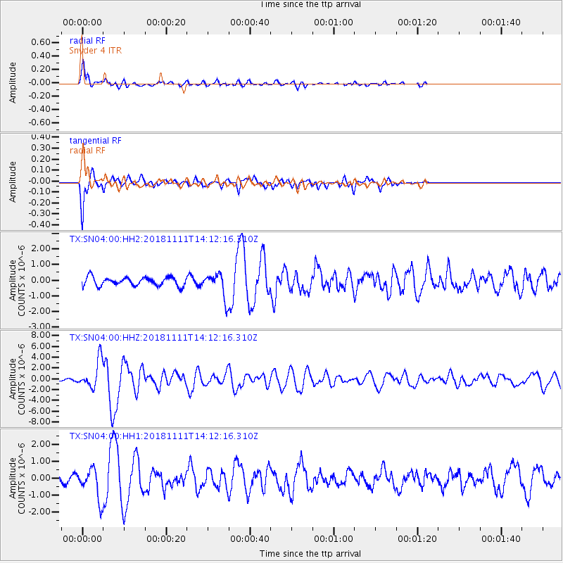
| Radial Match: |
84.36576 % |
| Radial Bump: |
400 |
| Transverse Match: |
87.8729 % |
| Transverse Bump: |
314 |
| SOD ConfigId: |
3131071 |
| Insert Time: |
2018-11-25 14:23:52.798 +0000 |
| GWidth: |
2.5 |
| Max Bumps: |
400 |
| Tol: |
0.001 |
|
Signal To Noise
| Channel | StoN | STA | LTA |
| TX:SN04:00:HHZ:20181111T14:12:16.310Z | 13.16902 | 2.6696036E-6 | 2.0271848E-7 |
| TX:SN04:00:HH1:20181111T14:12:16.310Z | 4.616452 | 9.195097E-7 | 1.9918103E-7 |
| TX:SN04:00:HH2:20181111T14:12:16.310Z | 2.912961 | 8.02831E-7 | 2.7560648E-7 |
| Arrivals |
| Ps | 1.5 SECOND |
| PpPs | 5.7 SECOND |
| PsPs/PpSs | 7.2 SECOND |


