You are here: Home > Network List > XA97 - Anatomy of an Archean Craton, South Africa Stations List
> Station SA45 XA.SA45 > Earthquake Result Viewer
SA45 XA.SA45 - Earthquake Result Viewer
| Earthquake location: |
South Sandwich Islands Region |
| Earthquake latitude/longitude: |
-59.7/-29.2 |
| Earthquake time(UTC): |
1997/10/05 (278) 18:04:30 GMT |
| Earthquake Depth: |
274 km |
| Earthquake Magnitude: |
6.0 MB, 6.3 UNKNOWN, 6.3 MW |
| Earthquake Catalog/Contributor: |
WHDF/NEIC |
|
| Network: |
XA Anatomy of an Archean Craton, South Africa |
| Station: |
SA45 XA.SA45 |
| Lat/Lon: |
24.88 S/26.16 E |
| Elevation: |
1015 m |
|
| Distance: |
51.5 deg |
| Az: |
72.666 deg |
| Baz: |
212.161 deg |
| Ray Param: |
0.06632362 |
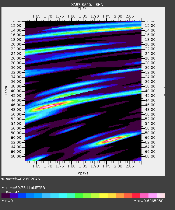
| Estimated Moho Depth: |
60.75 km |
| Estimated Crust Vp/Vs: |
1.97 |
| Assumed Crust Vp: |
6.459 km/s |
| Estimated Crust Vs: |
3.279 km/s |
| Estimated Crust Poisson's Ratio: |
0.33 |
|
| Radial Match: |
82.682846 % |
| Radial Bump: |
400 |
| Transverse Match: |
72.5191 % |
| Transverse Bump: |
400 |
| SOD ConfigId: |
6273 |
| Insert Time: |
2010-02-26 18:15:04.771 +0000 |
| GWidth: |
2.5 |
| Max Bumps: |
400 |
| Tol: |
0.001 |
|
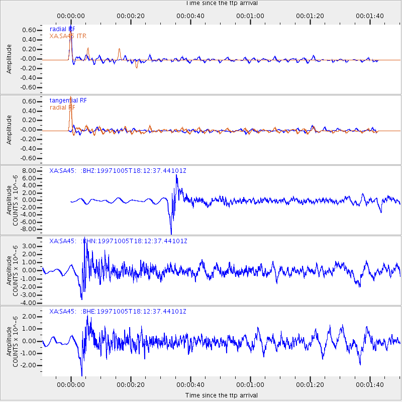
Signal To Noise
| Channel | StoN | STA | LTA |
| XA:SA45: :BHN:19971005T18:12:37.44101Z | 4.796089 | 1.4093125E-6 | 2.938462E-7 |
| XA:SA45: :BHE:19971005T18:12:37.44101Z | 3.4181063 | 9.053288E-7 | 2.6486268E-7 |
| XA:SA45: :BHZ:19971005T18:12:37.44101Z | 8.025038 | 3.0089125E-6 | 3.749406E-7 |
| Arrivals |
| Ps | 9.6 SECOND |
| PpPs | 27 SECOND |
| PsPs/PpSs | 36 SECOND |


