You are here: Home > Network List > TA - USArray Transportable Network (new EarthScope stations) Stations List
> Station T25A Trinidad, CO, USA > Earthquake Result Viewer
T25A Trinidad, CO, USA - Earthquake Result Viewer
| Earthquake location: |
Costa Rica |
| Earthquake latitude/longitude: |
9.2/-84.3 |
| Earthquake time(UTC): |
2010/05/20 (140) 22:16:30 GMT |
| Earthquake Depth: |
21 km |
| Earthquake Magnitude: |
5.6 MB, 5.6 MS, 5.9 MW, 5.9 MW |
| Earthquake Catalog/Contributor: |
WHDF/NEIC |
|
| Network: |
TA USArray Transportable Network (new EarthScope stations) |
| Station: |
T25A Trinidad, CO, USA |
| Lat/Lon: |
37.14 N/104.41 W |
| Elevation: |
2017 m |
|
| Distance: |
33.2 deg |
| Az: |
329.885 deg |
| Baz: |
141.698 deg |
| Ray Param: |
0.07829306 |
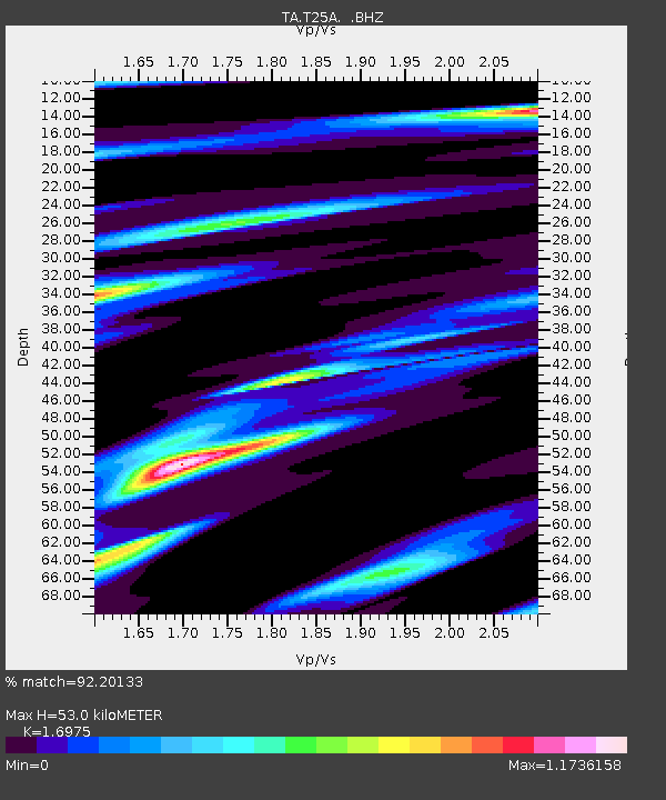
| Estimated Moho Depth: |
53.0 km |
| Estimated Crust Vp/Vs: |
1.70 |
| Assumed Crust Vp: |
6.316 km/s |
| Estimated Crust Vs: |
3.721 km/s |
| Estimated Crust Poisson's Ratio: |
0.23 |
|
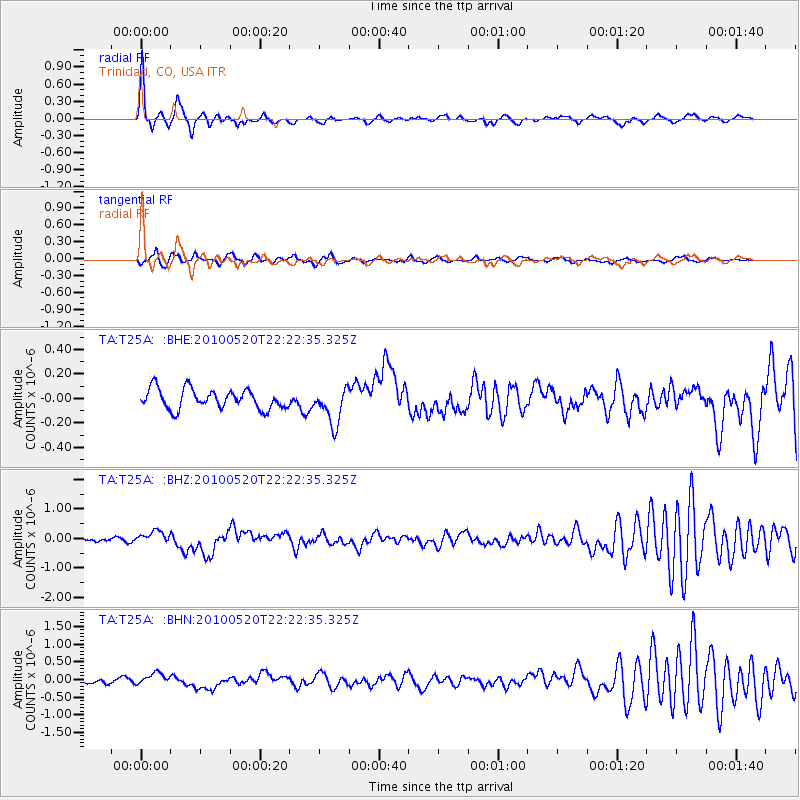
| Radial Match: |
92.20133 % |
| Radial Bump: |
312 |
| Transverse Match: |
78.34889 % |
| Transverse Bump: |
400 |
| SOD ConfigId: |
314592 |
| Insert Time: |
2010-09-04 08:23:54.073 +0000 |
| GWidth: |
2.5 |
| Max Bumps: |
400 |
| Tol: |
0.001 |
|
Signal To Noise
| Channel | StoN | STA | LTA |
| TA:T25A: :BHZ:20100520T22:22:35.325Z | 3.7451675 | 2.2164329E-7 | 5.918114E-8 |
| TA:T25A: :BHN:20100520T22:22:35.325Z | 1.6101025 | 1.6025452E-7 | 9.9530624E-8 |
| TA:T25A: :BHE:20100520T22:22:35.325Z | 1.8400034 | 1.4790156E-7 | 8.0381135E-8 |
| Arrivals |
| Ps | 6.3 SECOND |
| PpPs | 21 SECOND |
| PsPs/PpSs | 27 SECOND |


