You are here: Home > Network List > TA - USArray Transportable Network (new EarthScope stations) Stations List
> Station O23A Lake Granby, Granby, CO, USA > Earthquake Result Viewer
O23A Lake Granby, Granby, CO, USA - Earthquake Result Viewer

| Earthquake location: |
Costa Rica |
| Earthquake latitude/longitude: |
9.2/-84.3 |
| Earthquake time(UTC): |
2010/05/20 (140) 22:16:30 GMT |
| Earthquake Depth: |
21 km |
| Earthquake Magnitude: |
5.6 MB, 5.6 MS, 5.9 MW, 5.9 MW |
| Earthquake Catalog/Contributor: |
WHDF/NEIC |
|
| Network: |
TA USArray Transportable Network (new EarthScope stations) |
| Station: |
O23A Lake Granby, Granby, CO, USA |
| Lat/Lon: |
40.21 N/105.92 W |
| Elevation: |
2635 m |
|
| Distance: |
36.3 deg |
| Az: |
331.573 deg |
| Baz: |
142.147 deg |
| Ray Param: |
0.07670495 |
| Estimated Moho Depth: |
13.5 km |
| Estimated Crust Vp/Vs: |
2.07 |
| Assumed Crust Vp: |
6.306 km/s |
| Estimated Crust Vs: |
3.05 km/s |
| Estimated Crust Poisson's Ratio: |
0.35 |
|
| Radial Match: |
90.80739 % |
| Radial Bump: |
315 |
| Transverse Match: |
49.54127 % |
| Transverse Bump: |
400 |
| SOD ConfigId: |
314592 |
| Insert Time: |
2010-09-04 08:24:30.437 +0000 |
| GWidth: |
2.5 |
| Max Bumps: |
400 |
| Tol: |
0.001 |
|
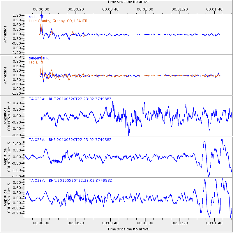
Signal To Noise
| Channel | StoN | STA | LTA |
| TA:O23A: :BHZ:20100520T22:23:02.374988Z | 4.097382 | 3.1140738E-7 | 7.600154E-8 |
| TA:O23A: :BHN:20100520T22:23:02.374988Z | 1.7500582 | 1.8879294E-7 | 1.0787809E-7 |
| TA:O23A: :BHE:20100520T22:23:02.374988Z | 1.2337519 | 1.0997146E-7 | 8.9135796E-8 |
| Arrivals |
| Ps | 2.4 SECOND |
| PpPs | 6.2 SECOND |
| PsPs/PpSs | 8.6 SECOND |


