You are here: Home > Network List > UU - University of Utah Regional Network Stations List
> Station GAWY Genesis Alkali Granger, WY, USA > Earthquake Result Viewer
GAWY Genesis Alkali Granger, WY, USA - Earthquake Result Viewer
| Earthquake location: |
North Atlantic Ocean |
| Earthquake latitude/longitude: |
15.6/-49.9 |
| Earthquake time(UTC): |
2018/11/11 (315) 14:03:59 GMT |
| Earthquake Depth: |
10 km |
| Earthquake Magnitude: |
6.2 mb |
| Earthquake Catalog/Contributor: |
NEIC PDE/us |
|
| Network: |
UU University of Utah Regional Network |
| Station: |
GAWY Genesis Alkali Granger, WY, USA |
| Lat/Lon: |
41.74 N/109.85 W |
| Elevation: |
2011 m |
|
| Distance: |
57.5 deg |
| Az: |
309.776 deg |
| Baz: |
98.197 deg |
| Ray Param: |
0.063464314 |
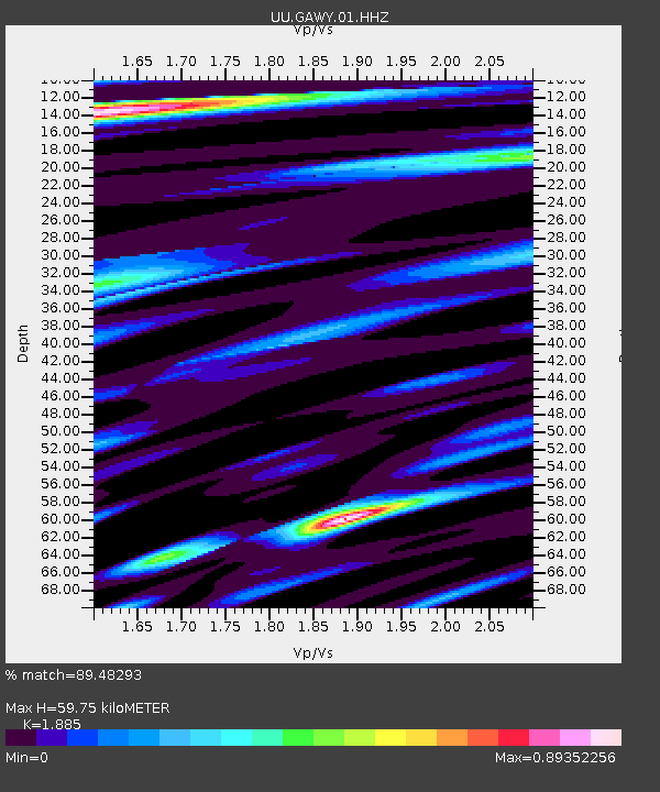
| Estimated Moho Depth: |
59.75 km |
| Estimated Crust Vp/Vs: |
1.88 |
| Assumed Crust Vp: |
6.207 km/s |
| Estimated Crust Vs: |
3.293 km/s |
| Estimated Crust Poisson's Ratio: |
0.30 |
|
| Radial Match: |
89.48293 % |
| Radial Bump: |
400 |
| Transverse Match: |
75.435875 % |
| Transverse Bump: |
400 |
| SOD ConfigId: |
3131071 |
| Insert Time: |
2018-11-25 14:25:53.922 +0000 |
| GWidth: |
2.5 |
| Max Bumps: |
400 |
| Tol: |
0.001 |
|

Signal To Noise
| Channel | StoN | STA | LTA |
| UU:GAWY:01:HHZ:20181111T14:13:17.599001Z | 7.0442 | 6.640586E-8 | 9.427026E-9 |
| UU:GAWY:01:HHN:20181111T14:13:17.599001Z | 1.5211508 | 1.525954E-8 | 1.0031575E-8 |
| UU:GAWY:01:HHE:20181111T14:13:17.599001Z | 1.8015828 | 1.878233E-8 | 1.04254605E-8 |
| Arrivals |
| Ps | 8.9 SECOND |
| PpPs | 27 SECOND |
| PsPs/PpSs | 35 SECOND |


