You are here: Home > Network List > UU - University of Utah Regional Network Stations List
> Station JLU Jordanelle, UT, USA > Earthquake Result Viewer
JLU Jordanelle, UT, USA - Earthquake Result Viewer
| Earthquake location: |
North Atlantic Ocean |
| Earthquake latitude/longitude: |
15.6/-49.9 |
| Earthquake time(UTC): |
2018/11/11 (315) 14:03:59 GMT |
| Earthquake Depth: |
10 km |
| Earthquake Magnitude: |
6.2 mb |
| Earthquake Catalog/Contributor: |
NEIC PDE/us |
|
| Network: |
UU University of Utah Regional Network |
| Station: |
JLU Jordanelle, UT, USA |
| Lat/Lon: |
40.60 N/111.45 W |
| Elevation: |
2285 m |
|
| Distance: |
58.5 deg |
| Az: |
308.265 deg |
| Baz: |
96.349 deg |
| Ray Param: |
0.06278311 |
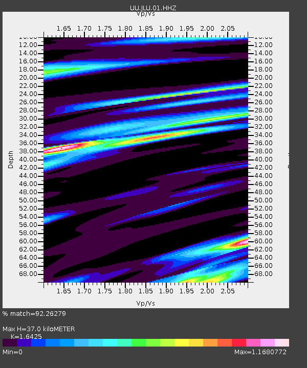
| Estimated Moho Depth: |
37.0 km |
| Estimated Crust Vp/Vs: |
1.64 |
| Assumed Crust Vp: |
6.155 km/s |
| Estimated Crust Vs: |
3.747 km/s |
| Estimated Crust Poisson's Ratio: |
0.21 |
|
| Radial Match: |
92.26279 % |
| Radial Bump: |
400 |
| Transverse Match: |
84.884125 % |
| Transverse Bump: |
400 |
| SOD ConfigId: |
3131071 |
| Insert Time: |
2018-11-25 14:26:00.333 +0000 |
| GWidth: |
2.5 |
| Max Bumps: |
400 |
| Tol: |
0.001 |
|

Signal To Noise
| Channel | StoN | STA | LTA |
| UU:JLU:01:HHZ:20181111T14:13:24.969973Z | 9.774141 | 3.5165716E-8 | 3.5978316E-9 |
| UU:JLU:01:HHN:20181111T14:13:24.969973Z | 1.8612784 | 7.735253E-9 | 4.1558823E-9 |
| UU:JLU:01:HHE:20181111T14:13:24.969973Z | 4.050622 | 1.6918266E-8 | 4.1767083E-9 |
| Arrivals |
| Ps | 4.1 SECOND |
| PpPs | 15 SECOND |
| PsPs/PpSs | 19 SECOND |


