You are here: Home > Network List > TA - USArray Transportable Network (new EarthScope stations) Stations List
> Station F24A Ekalaka, MT, USA > Earthquake Result Viewer
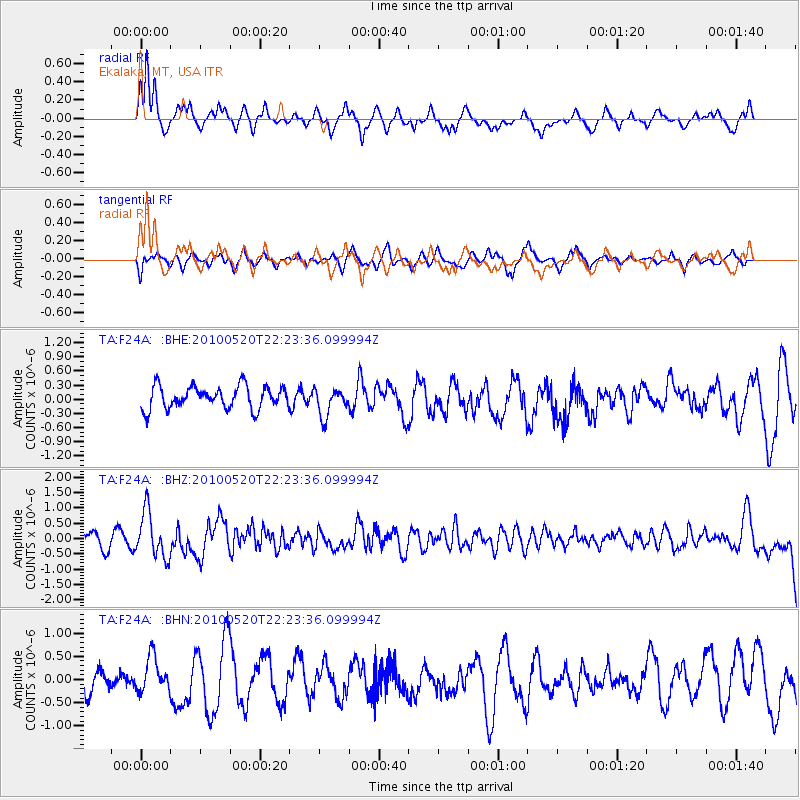
F24A Ekalaka, MT, USA - Earthquake Result Viewer
*The percent match for this event was below the threshold and hence no stack was calculated.
| Earthquake location: |
Costa Rica |
| Earthquake latitude/longitude: |
9.2/-84.3 |
| Earthquake time(UTC): |
2010/05/20 (140) 22:16:30 GMT |
| Earthquake Depth: |
21 km |
| Earthquake Magnitude: |
5.6 MB, 5.6 MS, 5.9 MW, 5.9 MW |
| Earthquake Catalog/Contributor: |
WHDF/NEIC |
|
| Network: |
TA USArray Transportable Network (new EarthScope stations) |
| Station: |
F24A Ekalaka, MT, USA |
| Lat/Lon: |
45.85 N/104.44 W |
| Elevation: |
1105 m |
|
| Distance: |
40.4 deg |
| Az: |
338.179 deg |
| Baz: |
148.335 deg |
| Ray Param: |
$rayparam |
*The percent match for this event was below the threshold and hence was not used in the summary stack. |
|
| Radial Match: |
63.14753 % |
| Radial Bump: |
299 |
| Transverse Match: |
50.21831 % |
| Transverse Bump: |
360 |
| SOD ConfigId: |
314592 |
| Insert Time: |
2010-09-04 08:28:38.819 +0000 |
| GWidth: |
2.5 |
| Max Bumps: |
400 |
| Tol: |
0.001 |
|
Signal To Noise
| Channel | StoN | STA | LTA |
| TA:F24A: :BHZ:20100520T22:23:36.099994Z | 4.265757 | 7.444926E-7 | 1.7452766E-7 |
| TA:F24A: :BHN:20100520T22:23:36.099994Z | 1.8114915 | 4.0612835E-7 | 2.2419556E-7 |
| TA:F24A: :BHE:20100520T22:23:36.099994Z | 1.2727535 | 3.0140635E-7 | 2.368144E-7 |
| Arrivals |
| Ps | |
| PpPs | |
| PsPs/PpSs | |


