You are here: Home > Network List > TA - USArray Transportable Network (new EarthScope stations) Stations List
> Station L25A Engebretsen Ranch, Morrill, NE, USA > Earthquake Result Viewer
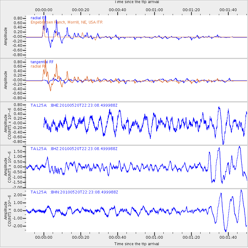
L25A Engebretsen Ranch, Morrill, NE, USA - Earthquake Result Viewer

| Earthquake location: |
Costa Rica |
| Earthquake latitude/longitude: |
9.2/-84.3 |
| Earthquake time(UTC): |
2010/05/20 (140) 22:16:30 GMT |
| Earthquake Depth: |
21 km |
| Earthquake Magnitude: |
5.6 MB, 5.6 MS, 5.9 MW, 5.9 MW |
| Earthquake Catalog/Contributor: |
WHDF/NEIC |
|
| Network: |
TA USArray Transportable Network (new EarthScope stations) |
| Station: |
L25A Engebretsen Ranch, Morrill, NE, USA |
| Lat/Lon: |
42.15 N/103.97 W |
| Elevation: |
1379 m |
|
| Distance: |
37.1 deg |
| Az: |
335.471 deg |
| Baz: |
146.553 deg |
| Ray Param: |
0.07631316 |
| Estimated Moho Depth: |
21.75 km |
| Estimated Crust Vp/Vs: |
1.60 |
| Assumed Crust Vp: |
6.483 km/s |
| Estimated Crust Vs: |
4.052 km/s |
| Estimated Crust Poisson's Ratio: |
0.18 |
|
| Radial Match: |
92.46056 % |
| Radial Bump: |
218 |
| Transverse Match: |
39.99773 % |
| Transverse Bump: |
400 |
| SOD ConfigId: |
314592 |
| Insert Time: |
2010-09-04 08:28:58.930 +0000 |
| GWidth: |
2.5 |
| Max Bumps: |
400 |
| Tol: |
0.001 |
|
Signal To Noise
| Channel | StoN | STA | LTA |
| TA:L25A: :BHZ:20100520T22:23:08.499988Z | 3.089038 | 4.0942598E-7 | 1.3254159E-7 |
| TA:L25A: :BHN:20100520T22:23:08.499988Z | 1.954684 | 3.233841E-7 | 1.6544061E-7 |
| TA:L25A: :BHE:20100520T22:23:08.499988Z | 1.63621 | 2.6117158E-7 | 1.5961984E-7 |
| Arrivals |
| Ps | 2.2 SECOND |
| PpPs | 8.0 SECOND |
| PsPs/PpSs | 10 SECOND |


