You are here: Home > Network List > UU - University of Utah Regional Network Stations List
> Station WPUT Wasatch Plateau, UT,USA > Earthquake Result Viewer
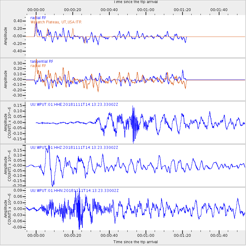
WPUT Wasatch Plateau, UT,USA - Earthquake Result Viewer

| Earthquake location: |
North Atlantic Ocean |
| Earthquake latitude/longitude: |
15.6/-49.9 |
| Earthquake time(UTC): |
2018/11/11 (315) 14:03:59 GMT |
| Earthquake Depth: |
10 km |
| Earthquake Magnitude: |
6.2 mb |
| Earthquake Catalog/Contributor: |
NEIC PDE/us |
|
| Network: |
UU University of Utah Regional Network |
| Station: |
WPUT Wasatch Plateau, UT,USA |
| Lat/Lon: |
39.00 N/111.36 W |
| Elevation: |
2618 m |
|
| Distance: |
58.3 deg |
| Az: |
306.403 deg |
| Baz: |
95.431 deg |
| Ray Param: |
0.06293582 |
| Estimated Moho Depth: |
15.25 km |
| Estimated Crust Vp/Vs: |
1.93 |
| Assumed Crust Vp: |
6.207 km/s |
| Estimated Crust Vs: |
3.212 km/s |
| Estimated Crust Poisson's Ratio: |
0.32 |
|
| Radial Match: |
88.46512 % |
| Radial Bump: |
400 |
| Transverse Match: |
76.22698 % |
| Transverse Bump: |
400 |
| SOD ConfigId: |
3131071 |
| Insert Time: |
2018-11-25 14:26:29.577 +0000 |
| GWidth: |
2.5 |
| Max Bumps: |
400 |
| Tol: |
0.001 |
|
Signal To Noise
| Channel | StoN | STA | LTA |
| UU:WPUT:01:HHZ:20181111T14:13:23.33002Z | 6.8721175 | 3.4591352E-8 | 5.0335798E-9 |
| UU:WPUT:01:HHN:20181111T14:13:23.33002Z | 1.0845827 | 7.7540925E-9 | 7.1493784E-9 |
| UU:WPUT:01:HHE:20181111T14:13:23.33002Z | 4.3532023 | 1.9305203E-8 | 4.434713E-9 |
| Arrivals |
| Ps | 2.4 SECOND |
| PpPs | 6.9 SECOND |
| PsPs/PpSs | 9.3 SECOND |


