You are here: Home > Network List > TA - USArray Transportable Network (new EarthScope stations) Stations List
> Station O27A Beecher Island, Eckley, CO, USA > Earthquake Result Viewer
O27A Beecher Island, Eckley, CO, USA - Earthquake Result Viewer
| Earthquake location: |
Costa Rica |
| Earthquake latitude/longitude: |
9.2/-84.3 |
| Earthquake time(UTC): |
2010/05/20 (140) 22:16:30 GMT |
| Earthquake Depth: |
21 km |
| Earthquake Magnitude: |
5.6 MB, 5.6 MS, 5.9 MW, 5.9 MW |
| Earthquake Catalog/Contributor: |
WHDF/NEIC |
|
| Network: |
TA USArray Transportable Network (new EarthScope stations) |
| Station: |
O27A Beecher Island, Eckley, CO, USA |
| Lat/Lon: |
40.19 N/102.48 W |
| Elevation: |
1206 m |
|
| Distance: |
34.8 deg |
| Az: |
335.249 deg |
| Baz: |
147.348 deg |
| Ray Param: |
0.07752538 |
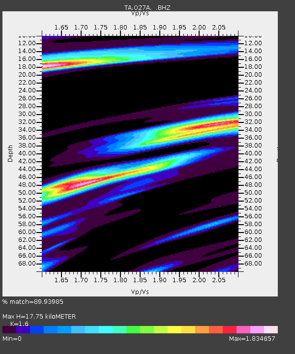
| Estimated Moho Depth: |
17.75 km |
| Estimated Crust Vp/Vs: |
1.60 |
| Assumed Crust Vp: |
6.483 km/s |
| Estimated Crust Vs: |
4.052 km/s |
| Estimated Crust Poisson's Ratio: |
0.18 |
|
| Radial Match: |
89.93985 % |
| Radial Bump: |
332 |
| Transverse Match: |
47.165222 % |
| Transverse Bump: |
392 |
| SOD ConfigId: |
314592 |
| Insert Time: |
2010-09-04 08:29:54.856 +0000 |
| GWidth: |
2.5 |
| Max Bumps: |
400 |
| Tol: |
0.001 |
|
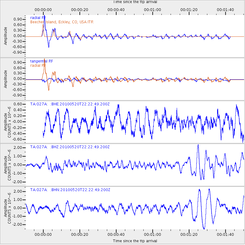
Signal To Noise
| Channel | StoN | STA | LTA |
| TA:O27A: :BHZ:20100520T22:22:49.200Z | 3.022397 | 4.882785E-7 | 1.6155339E-7 |
| TA:O27A: :BHN:20100520T22:22:49.200Z | 0.6705728 | 2.0437949E-7 | 3.0478344E-7 |
| TA:O27A: :BHE:20100520T22:22:49.200Z | 0.6277227 | 1.5274694E-7 | 2.4333505E-7 |
| Arrivals |
| Ps | 1.8 SECOND |
| PpPs | 6.5 SECOND |
| PsPs/PpSs | 8.3 SECOND |


