You are here: Home > Network List > TA - USArray Transportable Network (new EarthScope stations) Stations List
> Station T28A Walsh, CO, USA > Earthquake Result Viewer
T28A Walsh, CO, USA - Earthquake Result Viewer
| Earthquake location: |
Costa Rica |
| Earthquake latitude/longitude: |
9.2/-84.3 |
| Earthquake time(UTC): |
2010/05/20 (140) 22:16:30 GMT |
| Earthquake Depth: |
21 km |
| Earthquake Magnitude: |
5.6 MB, 5.6 MS, 5.9 MW, 5.9 MW |
| Earthquake Catalog/Contributor: |
WHDF/NEIC |
|
| Network: |
TA USArray Transportable Network (new EarthScope stations) |
| Station: |
T28A Walsh, CO, USA |
| Lat/Lon: |
37.12 N/102.11 W |
| Elevation: |
1148 m |
|
| Distance: |
32.1 deg |
| Az: |
332.601 deg |
| Baz: |
145.366 deg |
| Ray Param: |
0.07877573 |
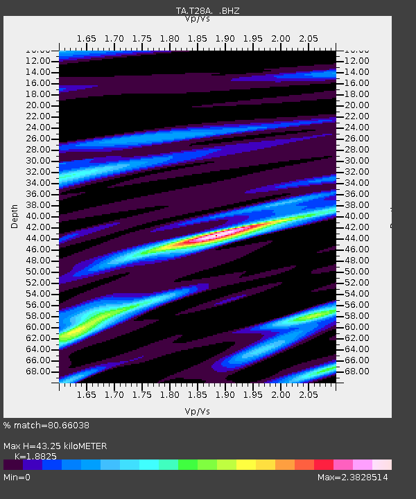
| Estimated Moho Depth: |
43.25 km |
| Estimated Crust Vp/Vs: |
1.88 |
| Assumed Crust Vp: |
6.306 km/s |
| Estimated Crust Vs: |
3.35 km/s |
| Estimated Crust Poisson's Ratio: |
0.30 |
|
| Radial Match: |
80.66038 % |
| Radial Bump: |
341 |
| Transverse Match: |
48.284676 % |
| Transverse Bump: |
396 |
| SOD ConfigId: |
314592 |
| Insert Time: |
2010-09-04 08:30:16.351 +0000 |
| GWidth: |
2.5 |
| Max Bumps: |
400 |
| Tol: |
0.001 |
|
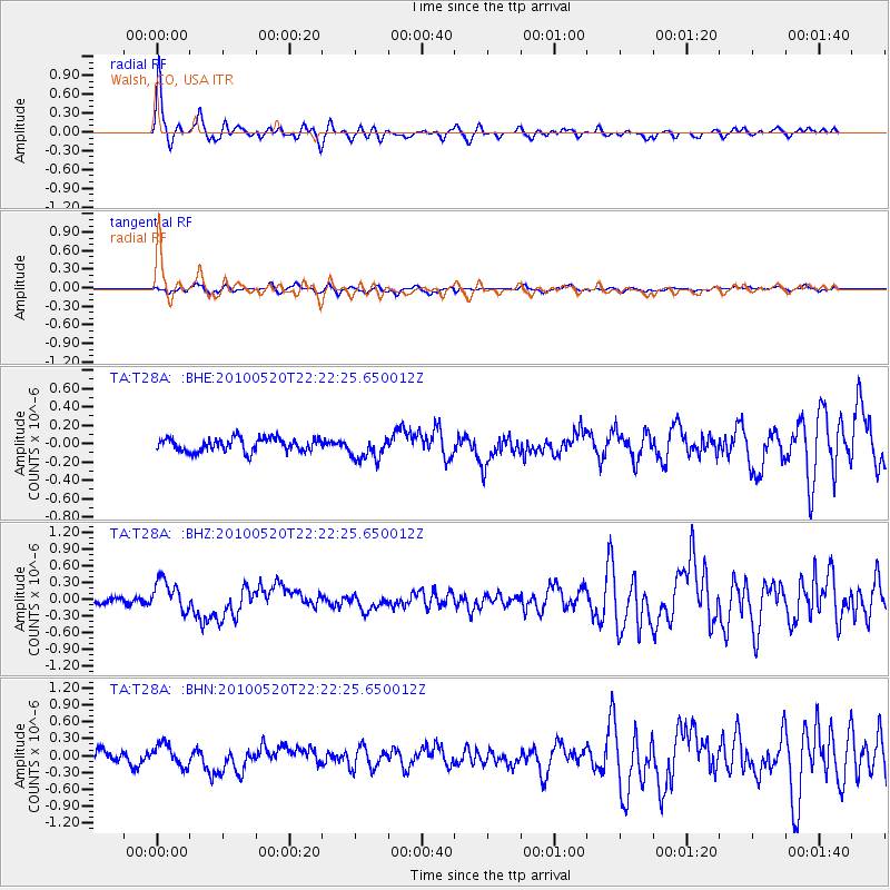
Signal To Noise
| Channel | StoN | STA | LTA |
| TA:T28A: :BHZ:20100520T22:22:25.650012Z | 3.983678 | 2.7888348E-7 | 7.000653E-8 |
| TA:T28A: :BHN:20100520T22:22:25.650012Z | 1.3268666 | 1.9176562E-7 | 1.4452517E-7 |
| TA:T28A: :BHE:20100520T22:22:25.650012Z | 1.7951988 | 1.304353E-7 | 7.2657855E-8 |
| Arrivals |
| Ps | 6.5 SECOND |
| PpPs | 18 SECOND |
| PsPs/PpSs | 25 SECOND |


