You are here: Home > Network List > TA - USArray Transportable Network (new EarthScope stations) Stations List
> Station T26A Comanche National Grassland Park, Kim, CO, USA > Earthquake Result Viewer
T26A Comanche National Grassland Park, Kim, CO, USA - Earthquake Result Viewer
| Earthquake location: |
Costa Rica |
| Earthquake latitude/longitude: |
9.2/-84.3 |
| Earthquake time(UTC): |
2010/05/20 (140) 22:16:30 GMT |
| Earthquake Depth: |
21 km |
| Earthquake Magnitude: |
5.6 MB, 5.6 MS, 5.9 MW, 5.9 MW |
| Earthquake Catalog/Contributor: |
WHDF/NEIC |
|
| Network: |
TA USArray Transportable Network (new EarthScope stations) |
| Station: |
T26A Comanche National Grassland Park, Kim, CO, USA |
| Lat/Lon: |
37.17 N/103.59 W |
| Elevation: |
1830 m |
|
| Distance: |
32.8 deg |
| Az: |
330.874 deg |
| Baz: |
143.019 deg |
| Ray Param: |
0.07846296 |
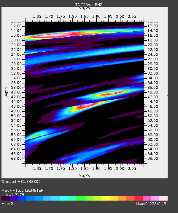
| Estimated Moho Depth: |
15.5 km |
| Estimated Crust Vp/Vs: |
1.72 |
| Assumed Crust Vp: |
6.306 km/s |
| Estimated Crust Vs: |
3.672 km/s |
| Estimated Crust Poisson's Ratio: |
0.24 |
|
| Radial Match: |
81.848305 % |
| Radial Bump: |
400 |
| Transverse Match: |
58.47566 % |
| Transverse Bump: |
400 |
| SOD ConfigId: |
314592 |
| Insert Time: |
2010-09-04 08:30:28.433 +0000 |
| GWidth: |
2.5 |
| Max Bumps: |
400 |
| Tol: |
0.001 |
|
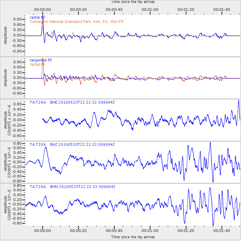
Signal To Noise
| Channel | StoN | STA | LTA |
| TA:T26A: :BHZ:20100520T22:22:32.099994Z | 3.2252564 | 3.543022E-7 | 1.09852415E-7 |
| TA:T26A: :BHN:20100520T22:22:32.099994Z | 1.6713208 | 1.6169444E-7 | 9.6746504E-8 |
| TA:T26A: :BHE:20100520T22:22:32.099994Z | 2.0664377 | 1.4944646E-7 | 7.2320816E-8 |
| Arrivals |
| Ps | 1.9 SECOND |
| PpPs | 6.2 SECOND |
| PsPs/PpSs | 8.1 SECOND |


