You are here: Home > Network List > WY - Yellowstone Wyoming Seismic Network Stations List
> Station YHR Hawk's Rest, WY, USA > Earthquake Result Viewer
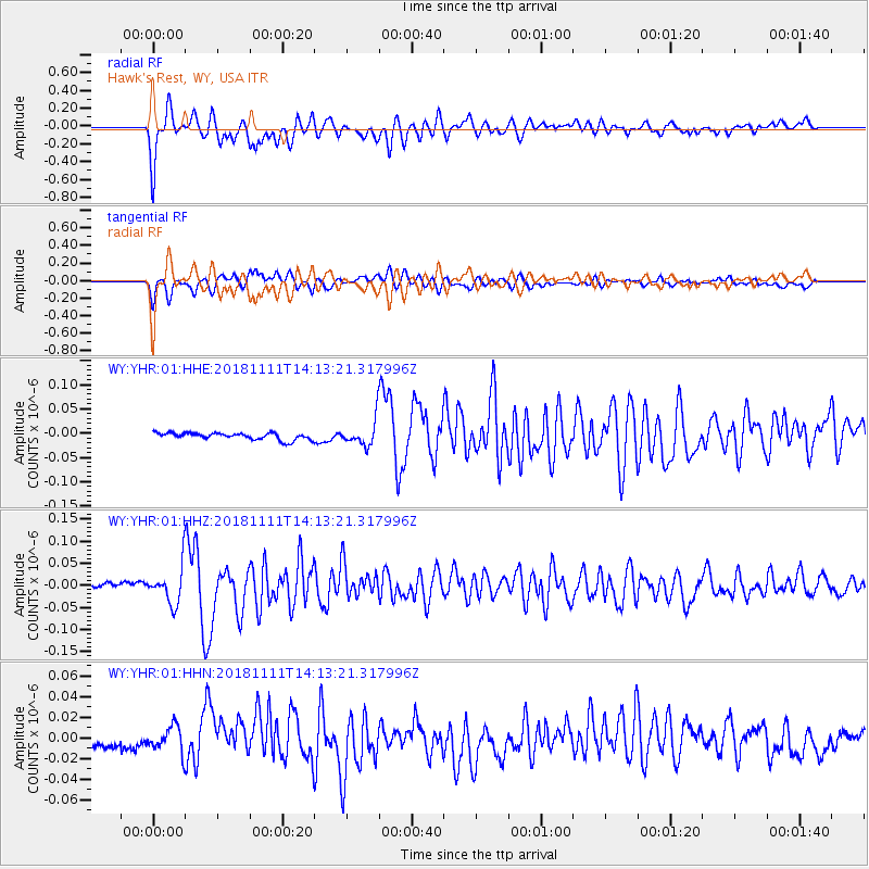
YHR Hawk's Rest, WY, USA - Earthquake Result Viewer
*The percent match for this event was below the threshold and hence no stack was calculated.
| Earthquake location: |
North Atlantic Ocean |
| Earthquake latitude/longitude: |
15.6/-49.9 |
| Earthquake time(UTC): |
2018/11/11 (315) 14:03:59 GMT |
| Earthquake Depth: |
10 km |
| Earthquake Magnitude: |
6.2 mb |
| Earthquake Catalog/Contributor: |
NEIC PDE/us |
|
| Network: |
WY Yellowstone Wyoming Seismic Network |
| Station: |
YHR Hawk's Rest, WY, USA |
| Lat/Lon: |
44.11 N/110.08 W |
| Elevation: |
2976 m |
|
| Distance: |
58.0 deg |
| Az: |
312.508 deg |
| Baz: |
99.5 deg |
| Ray Param: |
$rayparam |
*The percent match for this event was below the threshold and hence was not used in the summary stack. |
|
| Radial Match: |
88.6418 % |
| Radial Bump: |
400 |
| Transverse Match: |
83.141624 % |
| Transverse Bump: |
400 |
| SOD ConfigId: |
3131071 |
| Insert Time: |
2018-11-25 14:26:43.434 +0000 |
| GWidth: |
2.5 |
| Max Bumps: |
400 |
| Tol: |
0.001 |
|
Signal To Noise
| Channel | StoN | STA | LTA |
| WY:YHR:01:HHZ:20181111T14:13:21.317996Z | 7.136436 | 4.072231E-8 | 5.706253E-9 |
| WY:YHR:01:HHN:20181111T14:13:21.317996Z | 2.561845 | 1.25272885E-8 | 4.889948E-9 |
| WY:YHR:01:HHE:20181111T14:13:21.317996Z | 3.730774 | 2.6508049E-8 | 7.1052413E-9 |
| Arrivals |
| Ps | |
| PpPs | |
| PsPs/PpSs | |


